
Talk:Kinder Scout
| Jacob's Ladder, Derbyshire was nominated for deletion. The discussion was closed on 14 February 2024 with a consensus to merge. Its contents were merged into Kinder Scout. The original page is now a redirect to this page. For the contribution history and old versions of the redirected article, please see its history; for its talk page, see here. |
| The contents of the Jacob's Ladder, Derbyshire page were merged into Kinder Scout on 25 February 2024. For the contribution history and old versions of the redirected page, please see its history; for the discussion at that location, see its talk page. |
| This article is rated C-class on Wikipedia's content assessment scale. It is of interest to the following WikiProjects: | ||||||||||||||||||||||||||||||||||||||||||||||||||||||||
| ||||||||||||||||||||||||||||||||||||||||||||||||||||||||


Overgrazing?[edit]
is the surface of kinder scout the result of overgrazing? historically there must have been a lot more vegetation to supply create the peat.
Water over the edge?[edit]
Can anyone provide a source for this translation of Kinder Scout as meaning Water over the edge in Norse? I couldnt find this in a breif search of online Norse dictionaries. Also iI found this quote from
- "This obscure hill-name appears to be of pre-English origin, but the material is not adequatefor any certain etymology. It is the name of the highest hill in the Peak District."
K.Cameron, "The Place-Names of Derbyshire", 1959, p115 quoted in [1] Billlion 17:34, 3 Jan 2005 (UTC)
- I orginally put that it, I rembered reading it in a OS guide-book. I found this on't'web: [2]. Grinner 14:21, Jan 4, 2005 (UTC)
The etymology of "Kinder Scout" was discussed in 1880! (p71 in Manchester notes and queries. Ed. by J.H. Nodal. Vol.1-8 published by Manchester city news, 1880). One proposal therein suggested Kinder might be related to Kintire or Kintyre (from the gaelic caenn=head/point and tir=country/territory). Scout is more difficult.. maybe from the anglo-Saxon sceotan=shoot (just on example from the same source) as in "skeet" (clay pigeon shooting) which would be related to the waterfall (shooting over not shooting flying discs!). I like the idea (yes, OR!!) of Kintire's Cut (etymology of cut is straightforward meaning sliced or carved with a knife)or Kinder Scut?? (just as "a napron" became "an apron"). Viewed from the right direction Kinder Scout looks like a high piece of land that has a deep flesh wound!Softwarestorage (talk) 21:56, 6 September 2008 (UTC)
- Hmm. Exactly when was Gaelic supposed to have been spoken in Derbyshire...? Paul S (talk) 00:56, 12 April 2014 (UTC)
- I suppose "celtic" might be a better term than "gaelic". Celtic was spoken all over England, and the Anglo-Saxons simply took over or misunderstood some of the placenames. Hence, for instance, the large numbers of rivers Avon, Avon simply meaning River in celtic.--Martin Wyatt (talk) 14:13, 12 April 2014 (UTC)
Interestingly, there is a Kinderton in Cheshire, and the villages of Kenderchurch in Herefordshire and Llangynidr in Powys are said to be named after a Saint Cyndir who was a British Celtic bishop.Cadnant (talk) 05:50, 14 April 2017 (UTC)
If you look at the Scout Moor Wind Farm article it says "In England, scout hills are long ridges of rock, appearing to be "shot out" horizontally. Scout is a corruption of the Old English sceot, meaning "shot" or "to shoot", suggesting Anglo-Saxon settlement in the locality at a very ancient time". This is referenced to "Chetham Society (1856). Remains, Historical and Literary, Connected with the Palatine Counties of Lancaster and Chester. Chetham Society". Perhaps a look at that source would help. Richerman (talk) 15:38, 27 April 2014 (UTC)
- Dubious, pre-modern scholarship. There don't seem to be any other scout placenames in England and OE sceot wouldn't give modern English scout. Paul S (talk) 01:27, 3 May 2014 (UTC)
The word "sgwd" is used for a "waterfall" in parts of South Wales - the Dictionary of the Welsh Language describes "sgwd" (with several variants including "sgwt") as being of English origin meaning a chute or shoot of water. Cadnant (talk) 05:56, 14 April 2017 (UTC)
- Two and a quarter years on I've come across Scout Scar and guess what? - it has those horizontal bands of rock. Richerman (talk) 22:06, 29 August 2016 (UTC)
Access Land[edit]
The principal effects of the Kinder Trespass well pre-date Right to Roam, surely - The fact that a large area of the 'Dark Peak' was declared (many years ago) as 'Open Country' was the main effect. The CRoW bill was more a consequence of continuing access problems in upland areas like the Arans etc... Linuxlad 20:28, 25 Jan 2005 (UTC)
- I see what you're saying, but I think it is fair to regard the "right to roam" enshrined in the CRoW act as the culmination of the campaign that began with the Kinder trespass.Grinner 09:48, Jan 26, 2005 (UTC)
What it needs is a sentence _before_ the CRoW reference, to the earlier land designated 'open country' in the High Peak (many years pre-CRoW,and indeed dating from the Park's inception IIRC). (now done)
see also http://www.peakdistrict.org/crow/map.htm for the land so designated before and after 9/04
This issue came up over the Dartmoor article where the guy there claimed that that was the first English National Park to have 'open access' land, when it clearly wasn't. Linuxlad 14:33, 26 Jan 2005 (UTC)
Worth noting perhaps, that Tom Stephenson thought the Kinder Mass Trespass had done very little towards getting improved access IIRC Bob aka Linuxlad 23:07, 2 February 2007 (UTC)
Kinder Low - burial site?[edit]
I have a book here called The King's England. Written in 1937, it was intended to be a multi-part "Domesday book", and covers most villages in the UK. I have the Derbyshire book. Under the entry for Hayfield, it says something a little strange: "... Kinderscount, the great tableland wild and savage in rock and ravine.... culminating in the height of Kinder Low, where unknown men are sleeping in a mound 2088 feet above the sea."
I'm not sure if this is just flowery language, or whether he's saying there's a burial site there. What do you think? 86.135.161.239 (talk) 18:17, 11 May 2008 (UTC)
- Apparently there is a barrow up there: http://www.megalithic.co.uk/article.php?sid=12172 --VinceBowdren (talk) 22:29, 11 May 2008 (UTC)
- See also http://www.magic.gov.uk/rsm/23271.pdf Dave.Dunford (talk) 08:42, 12 May 2008 (UTC)
Of more interest is the fact that Kinder Low is a subsidiary high point of the plateau with a trig station. 'Low' is a local dialect word meaning summit which leads to the apparent oxymoron. [1] The reference confirms the trig station and the summit but it does not establish 'Low' meaning summit. If I can find a suitable dialect language reference, I'll add a landmark section for Kinder Low. OrewaTel (talk) 01:09, 21 August 2020 (UTC)
References
- ^ "TP4216 - Kinder Low". TP4216 - Kinder Low. Hill Explorer. Retrieved 21 August 2020.
External links[edit]
It is fine to have a link to the Hayfield website, but saying that it is the largest village that is a gateway to Kinder Scout is just advertising. The other village that is a "gateway to Kinder Scout" is Edale, which is probably better known as one end of the Pennine Way. --MWLittleGuy (talk) 18:21, 21 May 2010 (UTC)
Kinder Downfall as source of drinking water[edit]
I've removed the following good-faith edit, added by 86.15.101.71 (talk) here:
- The Downfall used to be accessible to fill up water bottles as it is one of the cleanest water sources on Kinder Scout, but due to the adverse weather conditions in late 2009 and early 2010, it has collapsed partially and is now avoided by most due to safety issues.
Several concerns: (a) I see no reason why the River Kinder would be any cleaner than any other watercourse on Kinder (in fact I'd expect the opposite; I've known sheep to hang around near the top, for example, and it sees more footfall than anywhere else on the plateau), so it may not be wise advice; (b) the adverse weather conditions are not a permanent feature so it suggests recentism; (c) one would assume from the stuff about collapse that the writer is talking about somewhere below or partway down the waterfall, which seems an unnecessarily difficult place to get to to fill a drinking bottle; (d) it reads as if the adverse weather caused the "collapse", which may not be what the author intended, and (e) that "avoided by most" makes me want to slap a [who?] on it. If the original author sees this, I'd be interested in their response. Dave.Dunford (talk) 09:36, 7 January 2011 (UTC)
- Response from my talk page:Dave.Dunford (talk) 11:59, 7 March 2011 (UTC)
- Hello Dave, though i was not the writer for the whole sentence, i did however add the part on the adverse weather conditions. Reason being, because we had a guide on our hike up to the top, and he was saying that there way as way back down Kinder just near the downfall, and that we would be able to fill up our water bottles here. Finding that the route had partially collapsed, we decided to head back, knowing that we had no water, and the only water sources available, were tainted with what he suspected to be Carbolic Acid, and to drink such taint would cause us stomach upsets and the like.
- The edit was in good faith, as i wished to notify anyone that still believed the downfall route was accessible. Obviously, not knowing Kinder Scout that well myself, i took the guides word with a grain of salt. The edit in question, may not have been up to Wikipedia's standards, as i'm not a big contributor, but i hoped, that someone might clean it up after i edited.
- Hope this clears things up for you Dave, and i do not resent you removing the post in the slightest. — Preceding unsigned comment added by Shaunyrawrs (talk • contribs) 01:30, 7 March 2011 (UTC)
- Interesting, there's never been a sane (worthwhile at least) way down for humans in my memory of Kinder Downfall for the top - getting on for 20 years now. As for carbolic acid, not so much from water from the plateau. It's mostly just been through peat for a few weeks/months depending on the weather. In the caves under the hills it can be higher levels but the open streams you tend to see haven't been through the cave system. The bigger worry for me out there tends to be there might be a dead sheep a few hundred meters upstream :) --Streaky (talk) 04:25, 18 August 2012 (UTC)
Line of sight to the Great Orme?[edit]
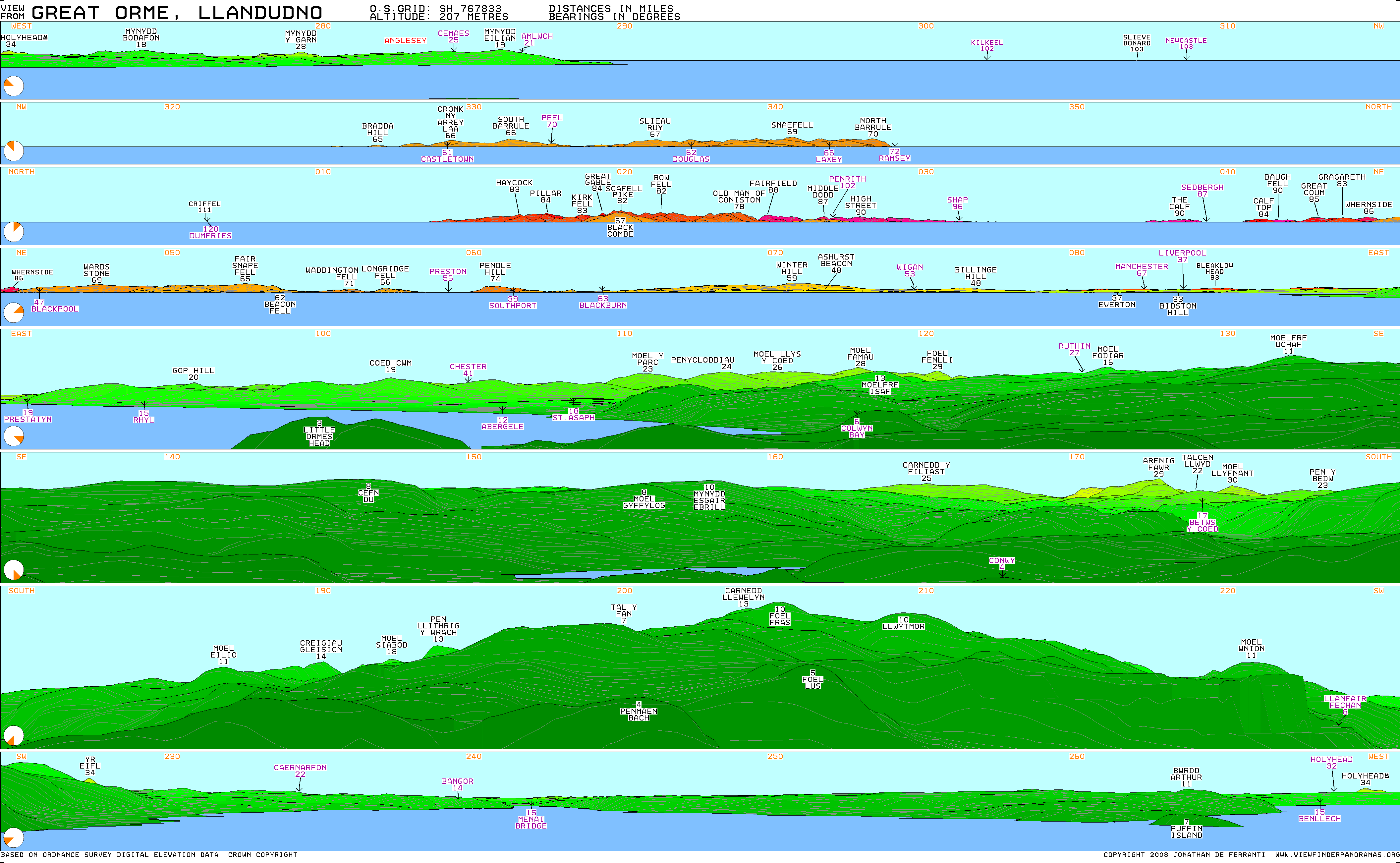
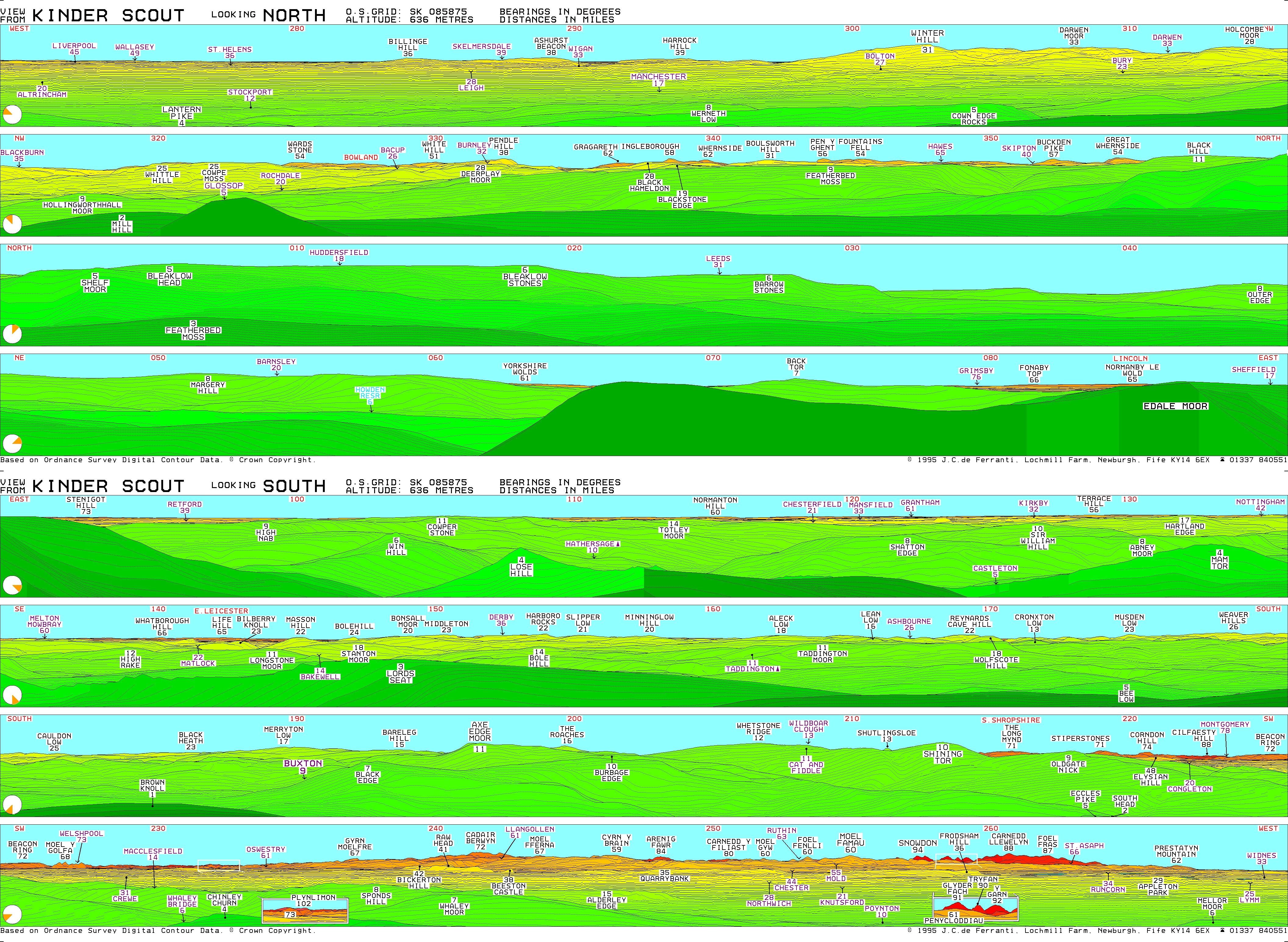
Does anyone know whether there is a line of sight from Kinder Scout to see the Great Orme on a very clear day? DFH (talk) 16:02, 8 June 2012 (UTC)
- This computer-generated panorama suggests that you can see nearby Bleaklow from the Great Orme (between 080° and 090°), so it doesn't seem beyond the realms of possibility that the Great Orme can be seen from Kinder (though the Kinder panorama at http://www.viewfinderpanoramas.org/panoramas/ENG/KINDERSCOUT.GIF doesn't mention it explicitly, and the hills around Prestatyn may be in the way). Dave.Dunford (talk) 14:01, 11 June 2012 (UTC)
- Closer examination of http://www.viewfinderpanoramas.org/panoramas/WAL/GREAT%20ORME.gif appears to show some high ground south of Bleaklow, which must surely be the Kinder plateau (although it's not labelled as such), and the hills above Prestatyn are further to the southeast, so it seems plausible that the reverse view is possible. Whether you'd be able to pick out the Great Orme at a distance of more than 80 miles in practice is another matter. I've confidently identified Snowdon (over 90 miles away) from the Peak District, but Snowdon is rather more prominent than the Great Orme! Dave.Dunford (talk) 14:09, 11 June 2012 (UTC)
Merger proposal[edit]
I propose that Mermaid's Pool (Peak District) be merged into Kinder Scout. The former was originally created as a joke, and although it's improved since, I doubt it will ever grow much beyond its current stubby incarnation. I suggest incorporating its information into the section "Mermaid legend" (which should perhaps be retitled "Mermaid's Pool"). Dave.Dunford (talk) 22:27, 8 March 2014 (UTC)
- That said, there's quite a lot of information (albeit acknowledged folklore) at http://mondrem.net/myths/Mermaids_Pool.html. Dave.Dunford (talk) 22:33, 8 March 2014 (UTC)
- I don't have a strong view on this, but I think I'd be inclined to leave it separate at least for the time being, for 2 reasons: first, the Mermaid's Pool article gets a reasonable volume of reader traffic (averaging about 30 per day over the last 3 months), and second because the Kinder Scout article is actually rather short itself, so significant expansion of the Mermaid's Pool section within it might make the article a bit unbalanced, with lots about the folklore attached to just one small pool, but nothing (as yet) about management or ecology, for example, which are surely more important. PaleCloudedWhite (talk) 08:40, 9 March 2014 (UTC)
- Fair points. Likewise, I don't feel strongly, but the notability of the Mermaid's Pool article has been questioned so I thought I'd see what opinion was here. Happy to let sleeping dogs lie. Dave.Dunford (talk) 18:03, 9 March 2014 (UTC)
- Following the merging of Jacob's Ladder, Derbyshire into this article, should we reconsider the above? Dave.Dunford (talk) 14:53, 25 February 2024 (UTC)
- Fair points. Likewise, I don't feel strongly, but the notability of the Mermaid's Pool article has been questioned so I thought I'd see what opinion was here. Happy to let sleeping dogs lie. Dave.Dunford (talk) 18:03, 9 March 2014 (UTC)
- C-Class UK geography articles
- Low-importance UK geography articles
- C-Class British and Irish hills articles
- WikiProject British and Irish hills articles
- C-Class Derbyshire articles
- High-importance Derbyshire articles
- Derbyshire articles needing maps
- WikiProject Derbyshire articles
- C-Class Protected areas articles
- Low-importance Protected areas articles
- Articles of WikiProject Protected areas