
Harden, New South Wales
| Harden New South Wales | |||||||||
|---|---|---|---|---|---|---|---|---|---|
 | |||||||||
 Harden | |||||||||
| Coordinates | 34°33′11″S 148°21′46″E / 34.55306°S 148.36278°E | ||||||||
| Population | 1,900 (SAL 2021)[1] | ||||||||
| Postcode(s) | 2587 | ||||||||
| Elevation | 431 m (1,414 ft) | ||||||||
| Location |
| ||||||||
| LGA(s) | Hilltops Council | ||||||||
| State electorate(s) | Cootamundra | ||||||||
| Federal division(s) | Riverina | ||||||||
| |||||||||


Harden–Murrumburrah is a township and community in the Hilltops Region and is located in the South West Slopes of New South Wales in Australia. Harden is adjacent to both the Canberra region of the Australian Capital Territory and the Riverina Region in the southwest area of NSW. The town is a twin town between Harden and Murrumburrah (which is noted as one of the earliest European immigrant settlements in the southwest of New South Wales).
The town is traversed by the Burley Griffin Way, the major link from and between the Riverina and the Hume Highway near Yass, and ultimately Sydney, Canberra and the coast. Cunningham Creek runs along the edge of the town.
The Olympic Highway traverses the western end of the shire and is the major link through the central west to the Blue Mountains and from there to the Sydney region.
Harden is 3½ hours away by road from Sydney, and 1½ hours from Canberra and Wagga Wagga.
History[edit]
Before European settlement the Harden area was inhabited by the Wiradjuri people. Hume and Hovell passed nearby in 1824. In the late 1820s, the 'Murrumburra' was established. Its superintendent, James Kennedy, established an inn on the townsite in the late 1840s. Gold was found in the area in the 1850s.[2]
Harden railway station was opened one km east of Murrumburrah on the Main Southern line in 1877 as Murrumburrah, but changed its name to Harden a year after the opening of a new station in Murrumburrah in 1879. Harden has remained as the main station and, as a result, became the main town.[3]
A post office at Harden was opened on 1 January 1870,[4] and in 1926 £2000 of funding was secured to provide extensive improvements to the ageing facility.[5]
The first Australian Lighthorse was also founded in Harden–Murrumburrah, with the Lighthorse festival occurring annually.
From 1906 until 2016 Harden–Murrumburrah was the seat of its own local council, but was amalgamated in 2016 to form Hilltops Council. The town's rugby league team, the Harden-Murrumburrah Hawks, competed for the Maher Cup, and continue to compete in senior football today in the George Tooke Shield.
In 1996, a trust was formed through the last will and testament of Geoffrey Kruger, a retired dental surgeon who had lived in the town for much of his life, the Kruger Trust was intended to fund improvements to the town itself. [6] The trust has funded key infrastructure in the town, such as a medical centre and community country club. [7]
Harden is also home to Murrumburrah High School, which was established in 1977 and is currently the only secondary education facility for the town.[8]
Facilities[edit]
Harden boasts a variety of facilities servicing residents from both Harden, Murrumburrah and surrounds.
- Harden-Murrumburrah & District War Memorial Pool; containing a 50-metre Olympic swimming pool as well as two smaller wading pools.[9]
- Harden Post Office[10]
- Hilltops Council Library Harden Branch located inside the Trinity Centre.[11]
- Kruger Medical Centre, a healthcare facility with General Practitioners providing healthcare for chronic disease management, as well as family medicine, womens health and mental health.[12]
- Murrumburrah High School; a secondary education facility.[8]
- Murrumburrah-Harden Health Service, a small hospital facility with 33 beds including 13 hospital care beds and 20 residential aged care beds. The facility sits under the Murrumbidgee Local Health District.[13]
Climate[edit]
Harden experiences a climate typical of the South West Slopes, with a large seasonal variation throughout the year. Under Koppen it is classified as a humid subtropical climate (Köppen: Cfa, Trewartha: Cfbl/Cfal) with warm to hot summers and cool, cloudy winters. On rare occasions it may snow.
Temperature data were collected from 1967 until 1980, and rainfall from 1886 until 2006.
| Climate data for Harden (East St, 1967–1980, rainfall 1886–2006); 430 m AMSL; 34.56° S, 148.37° E | |||||||||||||
|---|---|---|---|---|---|---|---|---|---|---|---|---|---|
| Month | Jan | Feb | Mar | Apr | May | Jun | Jul | Aug | Sep | Oct | Nov | Dec | Year |
| Record high °C (°F) | 41.8 (107.2) |
41.7 (107.1) |
36.5 (97.7) |
30.6 (87.1) |
26.1 (79.0) |
21.5 (70.7) |
19.5 (67.1) |
25.0 (77.0) |
29.5 (85.1) |
34.6 (94.3) |
36.1 (97.0) |
40.0 (104.0) |
41.8 (107.2) |
| Mean daily maximum °C (°F) | 30.4 (86.7) |
30.4 (86.7) |
27.4 (81.3) |
22.2 (72.0) |
17.0 (62.6) |
14.0 (57.2) |
13.0 (55.4) |
14.6 (58.3) |
17.4 (63.3) |
21.5 (70.7) |
25.0 (77.0) |
29.1 (84.4) |
21.8 (71.3) |
| Mean daily minimum °C (°F) | 14.5 (58.1) |
15.0 (59.0) |
12.3 (54.1) |
7.7 (45.9) |
4.4 (39.9) |
1.9 (35.4) |
1.0 (33.8) |
2.2 (36.0) |
3.7 (38.7) |
6.8 (44.2) |
9.1 (48.4) |
11.9 (53.4) |
7.5 (45.6) |
| Record low °C (°F) | 4.5 (40.1) |
5.7 (42.3) |
2.0 (35.6) |
−3.0 (26.6) |
−5.0 (23.0) |
−5.0 (23.0) |
−6.9 (19.6) |
−7.5 (18.5) |
−3.5 (25.7) |
−1.5 (29.3) |
1.0 (33.8) |
2.5 (36.5) |
−7.5 (18.5) |
| Average rainfall mm (inches) | 50.7 (2.00) |
42.2 (1.66) |
50.0 (1.97) |
45.7 (1.80) |
46.3 (1.82) |
58.1 (2.29) |
53.1 (2.09) |
53.4 (2.10) |
53.1 (2.09) |
58.4 (2.30) |
47.1 (1.85) |
49.6 (1.95) |
607.7 (23.92) |
| Average rainy days (≥ 0.2 mm) | 5.2 | 4.6 | 4.8 | 5.5 | 7.1 | 9.6 | 10.6 | 10.3 | 8.8 | 8.3 | 6.4 | 5.3 | 86.5 |
| Source: Australian Bureau of Meteorology[14] | |||||||||||||
Heritage listings[edit]
Harden has a number of heritage-listed sites, including:
- Main Southern railway: Harden railway station[15]
Population[edit]
According to the 2016 census of population, there were 2,030 people in Harden.[16] At the 2021 census, this had dropped to 1,900 people.[17]
- Aboriginal and Torres Strait Islander people made up 8.7% of the population.
- 84.6% of people were born in Australia and 90.7% of people only spoke English at home.
- The most common responses for religion were Catholic 31.3%, No Religion 24.9% and Anglican 24.6%.
Transport[edit]
The Main Southern railway line passes through Harden. It became an important railway town with the line to Blayney branching off a few kilometres beyond Harden at Demondrille. Harden railway station is served by two daily NSW TrainLink XPT services between Melbourne and Sydney in each direction and the twice weekly Xplorer service between Griffith and Sydney.[18] NSW TrainLink trial road coach services 703 and 704 between Wagga Wagga and Canberra via Cootamundra pass through Harden, but as at September 2019 do not pick up or drop off passengers there.[19] Busabout Wagga Wagga have a depot in the town.[20]
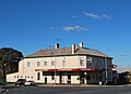
Gallery[edit]
-
 Harden National Australia Bank
 -
 Harden Mechanics Institute
 -
 Harden Post office
 -
 Royal Hotel
 -
 Grand Hotel Harden
 -
 Harden Doncaster Hotel
 -
 Harden Carrington Hotel
 -
 Former Harden Methodist Church
 -
 Harden Catholic Church
 -
 Harden Trinity Centre
 -
 Hilltops Council Office
 -
 "Bill the Bastard"
 -
 Town sign


See also[edit]
Notes[edit]
- ^ Australian Bureau of Statistics (28 June 2022). "Harden (suburb and locality)". Australian Census 2021 QuickStats. Retrieved 28 June 2022.
- ^ "Harden". Walkabout, John Fairfax. Archived from the original on 3 October 2006. Retrieved 25 January 2007.
- ^ "Harden Railway Station". www.nswrail.net. Retrieved 25 January 2007.
- ^ Phoenix Auctions History. "Post Office List". Phoenix Auctions. Retrieved 10 February 2021.
- ^ "NEW POST OFFICE FOR HARDEN". Cootamundra Herald. 28 October 1926. Retrieved 29 December 2022.
- ^ "Poll Provides Insight to Feelings Regarding Kruger Trust - Twin Town Times". 6 October 2019.
- ^ "Harden wants to be Canberra's friendliest, most affordable neighbour".
- ^ a b "Home - Murrumburrah High School". murrumburr-h.schools.nsw.gov.au. Retrieved 29 December 2022.
- ^ "Harden". Hilltops Council. Retrieved 29 December 2022.
- ^ "HMS - ViewItem". www.hms.heritage.nsw.gov.au. Retrieved 29 December 2022.
- ^ "Harden Library". Hilltops Council Library. Retrieved 29 December 2022.
- ^ "Kruger Medical Centre Harden | Chronic Diseases, Family Medicine". Kruger Medical Centre. Retrieved 29 December 2022.
- ^ "Murrumburrah-Harden Health Service". NSW Government Health Murrumbidgee Local Health District. 13 September 2022. Retrieved 29 December 2022.
- ^ "Harden (East St)". Australian Bureau of Meteorology. Retrieved 7 December 2023.
- ^ "Harden Railway Station and yard group". New South Wales State Heritage Register. Department of Planning & Environment. H01165. Retrieved 18 May 2018.
 Text is licensed by State of New South Wales (Department of Planning and Environment) under CC-BY 4.0 licence.
- ^ Australian Bureau of Statistics (27 June 2017). "2016 Community Profiles: Harden". 2016 Census of Population and Housing. Material was copied from this source, which is available under a Creative Commons Attribution 4.0 International License.
- ^ "2021 Harden, Census All persons QuickStats". Australian Bureau of Statistics. Retrieved 15 August 2022.
- ^ "Southern timetable". NSW TrainLink. 7 September 2019.
- ^ Wagga Wagga to Canberra NSW TrainLink
- ^ Harden Depot School Bus Services Busabout Wagga Wagga
External links[edit]
![]() Media related to Harden, New South Wales at Wikimedia Commons
Media related to Harden, New South Wales at Wikimedia Commons
| Preceding station | Following station | |||
|---|---|---|---|---|
| Cootamundra | NSW TrainLink Southern Line Griffith Xplorer
Melbourne XPT |
Yass Junction towards Sydney
| ||
| Authority control databases: National |
|---|