
A58 road
 | ||||
|---|---|---|---|---|
 | ||||
 | ||||
| Route information | ||||
| Length | 75 mi (121 km) | |||
| Major junctions | ||||
| West end | ||||
| ||||
| East end | ||||
| Location | ||||
| Country | United Kingdom | |||
| Primary destinations | St Helens Bolton Bury Rochdale Halifax Leeds | |||
| Road network | ||||
| ||||
The A58 is a major road in Northern England running between Prescot, Merseyside and Wetherby, West Yorkshire.
Route from West to East[edit]
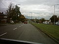
Its westbound start is at Prescot on the outskirts of Liverpool via Greater Manchester and West Yorkshire to the eastern terminus at Wetherby. The road goes through the following locations:
- St Helens
- Ashton-in-Makerfield
- Hindley
- Westhoughton
- Bolton
- Bury
- Heywood
- Rochdale
- Littleborough
- The Pennines
- Ripponden
- Sowerby Bridge
- Halifax
- Hipperholme
- Birkenshaw
- Drighlington
- New Farnley
- Leeds City Centre as the A58(M) motorway (part of the Leeds Inner Ring Road),
- Scarcroft
- Bardsey
- Collingham
- to its terminus at Wetherby
History[edit]
Leeds to Wetherby[edit]
The original route between Leeds and Wetherby has a dual carriageway diverting from Roundhay Road/Wetherby Road, at the old Fforde Grene junction in Harehills. It runs along the Easterly Road dual carriageway passing Oakwood and Gipton. The re-routed A58 meets its original route at Boggart Hill in Seacroft. The re-routed section was constructed in the 1930s and had a branch of the Leeds Tramway running along the central reservation until the 1950s.[1] The proposed Leeds Supertram was also to run this route.[2]
Gallery[edit]
-

-
-
 A58(M), Leeds Inner Ring Road by the Leeds International Pool
 -
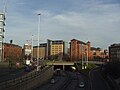 A58(M), Leeds Inner Ring Road passing underneath the Nuffield Hospital


References[edit]
- ^ Buckley, Richard (2011). Leeds Trams 1871–1959. Catrine: Stenlake. p. 54. ISBN 9781840335309.
- ^ "Leeds Supertram Route Map". Railway Technology. Retrieved 20 March 2016.
External links[edit]
![]() Media related to A58 road (England) at Wikimedia Commons
Media related to A58 road (England) at Wikimedia Commons
A roads in Zone 5 of the Great Britain road numbering scheme | ||
|---|---|---|
53°54′18″N 2°09′01″W / 53.90499°N 2.15023°W
This England road or road transport-related article is a stub. You can help Wikipedia by expanding it. |