
Celestún
This article needs additional citations for verification. (December 2010) |
Celestun | |
|---|---|
Town | |
 | |
 | |
 Celestun  Celestun | |
| Coordinates: 20°51′30″N 90°24′0″W / 20.85833°N 90.40000°W | |
| Country | |
| State | |
| Government | |
| • Municipal President | Araci Guadalupe Villanueva Pinto [1] |
| Population | |
| • Total | 6,269 |
| Municipality | |
| Time zone | UTC-6 (Central Standard Time) |
| • Summer (DST) | UTC-5 (Central Daylight Time) |
| INEGI Code | 011 |
| Major Airport | Merida (Manuel Crescencio Rejón) International Airport |
| IATA Code | MID |
| ICAO Code | MMMD |
| Website | Nuestros municipios - Celestún |
Celestún is a town in Yucatán, Mexico. It is located in the northwest corner of the state, just north of the border with the state of Campeche, on the Gulf of Mexico coast at 20°51.5′N 90°24′W / 20.8583°N 90.400°W.
On the town[edit]
In 2000, it had a population of just under 6,000 people; however, the population swells to 10,000 during the octopus hunting season. It is mostly a fishing town, with a 19th-century lighthouse (as well as a more modern one) and an abandoned historic hacienda[citation needed]. Besides fishing, Celestún also produces salt, as it has done from pre-Columbian times[citation needed]. Tourism is also making up an increasing portion of the town's economy, as the community has many kilometers of sand beaches and abundant wildlife.
One of the busiest times for tourism is Holy Week, when people from around the region visit Celestun. Local folk-catholic traditions are abundant during this time, when the town's patron saint is floated out to sea surrounded by candles, and visited by the patron saint of nearby Kinchil. There is a church in the town built during the colonial period
As the town of Celestun is the seat of the municipality (municipio) of Celestun, it attracts various carnivals, dances and musicians to its town square on a regular basis.
.JPG)
Geography[edit]
It is located in the northwest corner of the state, just north of the border with the state of Campeche.
Surrounding the town is the 147,500-acre (600 km2) Ría Celestún Biosphere Reserve, a wetland reserve that is the winter home to vast flocks of flamingos, as well as many herons and other bird species. This location is set within the Petenes mangroves ecoregion.[4] In addition, more than 200 species of birds pass through on migration, or live there.[5] Celestun's ecosystem is unique because of a combination of freshwater from the century estuary and saltwater from the Gulf of Mexico. The reserve also has two types of pelicans - large white Canadian and smaller gray Mexican ones. Celestun is also known as a hatching ground for endangered sea turtles. Wildlife conservationists have an ongoing project to protect the sea turtles from encroaching modernization.

Climate[edit]
| Climate data for Celestún | |||||||||||||
|---|---|---|---|---|---|---|---|---|---|---|---|---|---|
| Month | Jan | Feb | Mar | Apr | May | Jun | Jul | Aug | Sep | Oct | Nov | Dec | Year |
| Mean daily maximum °C (°F) | 29 (84) |
29.9 (85.8) |
32 (90) |
34.3 (93.7) |
35 (95) |
34.3 (93.7) |
33.8 (92.8) |
33.5 (92.3) |
32.9 (91.2) |
31.7 (89.1) |
30.2 (86.4) |
29.1 (84.4) |
32 (90) |
| Mean daily minimum °C (°F) | 17.3 (63.1) |
17.6 (63.7) |
19.0 (66.2) |
20.7 (69.3) |
22 (72) |
22.5 (72.5) |
22 (72) |
22.3 (72.1) |
22.4 (72.3) |
21.7 (71.1) |
20 (68) |
18.0 (64.4) |
20.5 (68.9) |
| Average precipitation cm (inches) | 2.5 (1) |
2.0 (0.8) |
0.76 (0.3) |
1.0 (0.4) |
3.6 (1.4) |
11 (4.3) |
12 (4.9) |
12 (4.8) |
14 (5.7) |
8.6 (3.4) |
3.3 (1.3) |
2.8 (1.1) |
75 (29.4) |
| Source: Weatherbase [6] | |||||||||||||
Ecological park[edit]

Nearby there is the Ría Celestun Biosphere Reserve.
Gallery[edit]
-
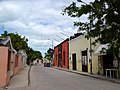 Street in Celestún
 -
 The lighthouse in Celestún beach
 -
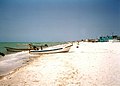
 A beach by Celestún
 -
 The church in Celestún
 -
 Flamingos
 -
 A beach by Celestún, 1999

.jpg)


References[edit]
- ^ "Nuestros municipios - Celestún". Archived from the original on 2009-12-04. Retrieved 2009-11-12.
- ^ "Encyclopedia of the Municipalities of Mexico: Yucatan". Archived from the original on 2008-11-20. Retrieved 2009-11-01.
- ^ Census Results by Locality, 2005 Archived July 22, 2011, at the Wayback Machine INEGI.
- ^ World Wildlife Fund. eds. Mark McGinley, C.Michael Hogan & C. Cleveland. 2010. Petenes mangroves. Encyclopedia of Earth. National Council for Science and the Environment. Washington DC Archived October 15, 2011, at the Wayback Machine
- ^ Brown, Clare. Brown, Karen. Stevenson Day, Jane -Karen Brown's Mexico: Exceptional Places to Stay and Itineraries, page 141. Karen Brown's Guides, 2006. ISBN 1-933810-10-6
- ^ "Weatherbase: Historical Weather for Celestún, Yucatán". Weatherbase. 2011.Retrieved on November 24, 2011.
External links[edit]
- Celestún Lagoon Photo Essay
- Karst and Colors on the Yucatán Peninsula near Celestún NASA Earth Observatory, May 8, 2022
Mérida (capital) | |||||||||||||||
| Topics |  | ||||||||||||||
| Metros | |||||||||||||||
| Larger cities | |||||||||||||||
| Smaller cities |
| ||||||||||||||
| Municipalities |
| ||||||||||||||
| International | |
|---|---|
| National | |
| Celestún Lighthouse | |