
Talk:Four corners (Canada)
| This article was nominated for deletion on 13 May 2013. The result of the discussion was keep. |
| This article is rated Start-class on Wikipedia's content assessment scale. It is of interest to the following WikiProjects: | ||||||||||||||||||||||||||
| ||||||||||||||||||||||||||


| Text and/or other creative content from Four Corners (Canada) was copied or moved into Quadripoint#National with this edit. The former page's history now serves to provide attribution for that content in the latter page, and it must not be deleted as long as the latter page exists. |
Not a Four Corners?[edit]
Are you sure that Canada has a "Four Corners"? Have a look at that "spot" with mapquest.com. You can zoom right in on it. See what I mean?
- No, I'm not sure what you mean. I looked at Mapquest and it doesnt' show any gap; there appears to be a four corners spot.
http://www.mapquest.com/directions/main.adp?go=1&do=nw&rmm=1&un=m&cl=EN&ct=NA&rsres=1&1ffi=&1l=&1g=&1pl=&1v=&1n=&2ffi=&2l=&2g=&2pl=&2v=&2n=&1pn=&1a=&1c=Miami&1s=FL&1z=&2pn=&2a=&2c=Flin+FLon&2s=MB&2z=&r=f (Please pardon the strange title of (driving directions from Miami to Flin Flon). I wanted a zoomed out map and don't know of any towns in the area.) By definition, the corner is at the intersection of 60°00′00″ North and 102°00′00″ West. It doesn't even make sense that such an offset would exist. The area is remote, so there are no towns to consider when creating the borders. The area is not of strategic imporantance either, so there's no reason why one territory or province would be "given" a little bit of extra land. I'm deleting this erroneous "did you know" from the article unless someone has a source. Ufwuct 19:10, 10 June 2006 (UTC)
- I just linked the coordinates. Of the 2 maps available from the coordinates that show the boundries, Mapquest shows no offset but Google maps do when you click on hybrid. However the external link to the Government of Canada's map shows no offset. You need to zoom in to see it. CambridgeBayWeather (Talk) 19:38, 10 June 2006 (UTC)
MSN Maps also shows this as an exact four-corners[1]. But as CambridgeBayWeather noted, Google Maps dows show an offset [2]. It would be interesting to find out what source material Google Maps used. Most likely, there are arguments on both sides as to whether there actually ought to be an offset or not. The reason has to do with differing geodetic systems. The current Manitoba-Saskatchewan boundary was set by the Manitoba Boundaries Extension Act (1881) [3] and the Saskatchewan Act (1905) [4], in terms of "road allowances" and so forth. That boundary really could not be exactly the same as what a GPS unit would today identify as 102° W longitude, because GPS uses the WGS84 geodetic system, which is standard today but had not yet been developed in 1881 or 1905. The obelisk referred to in the article is apparently at 59º59'59.6"N 102º00'22.3"W under the NAD27 reference [5], which converts to 60º00'00"N 102º00'25"W under WGS84 [6]. In other words it is about 25 seconds of longitude west of the 102nd meridian under the WGS84 datum, a distance of approximately 387 metres [7]. The Nunavut Act (1993) defined the western boundary of Nunavut as commencing at precisely 60°00'N 102°00'W (presumably according to WGS84 although that doesn't seem to be specified expressly). However, it goes on to describe that point as "being the intersection of the Manitoba, Northwest Territories and Saskatchewan borders" [8]. --Mathew5000 22:40, 10 June 2006 (UTC)
- The google map now has no offset [9]. I have transplanted a statement of doubt from the quadripoint article as it belongs here more than there. jnestorius(talk) 22:27, 3 January 2007 (UTC)
The NRC's "Canadian Geopolitical Boundaries - CANADA" page ([10]) defines a clear offset. Should we reword the article to clarify that this is not actually a quadripoint? Jkshapiro (talk) 19:24, 12 February 2015 (UTC)
- No. That's just a map, not a legal definition. The law is unclear, so it's right to say that it's possibly a quadripoint. Bazonka (talk) 19:34, 12 February 2015 (UTC)
- It's not known by the proper name and should not be the title this whack of ongoing original research, likewise Quadripoint which is a neologism propagating itself via Wikipedia; and is ultimately WP:TRIVIA. Aside from that if it's only possibly a "quadripoint" (and it's not, those maps are derived from legal land surveys which are the boundaries; the legal definitions are not boundaries, they are prescriptions only and if there are different legal definitions varying between provinces and/or the federal government, "Houston, we have a problem".
- That no genuine third-party source other than sites made by "quadripoint enthusiasts" uses this name, and it does not appear on maps, the title is not a proper name. About boundaries vs legislation, this is why the 49th Parallel boundary isn't exactly on the 49th Parallel; but the terms of the treaty, as with other legislation, only establish the survey lines; the line physically surveyed IS the boundary, not what the treaty (=legislation, effectively) says. Same with the Alaska boundary with NW BC and SW YT; it's the surveyed monuments that define it, not the documentation.
- To me this article and its title are pure WP:Original research as well as TRIVIA-based wiki-fiction. Other long-time editors have commented in the past, given failed AfDs to delete it, and the Quadripoint article, that it gives people something to do to keep them away from creating serious content, or messing with same.
- Whatever, I'm not going to try and AfD it again, but just observing that the original research and now entirely speculative nature of this non-place ("possibly a quadripoint", asserted without any understanding of the legalities just explained above, notwithstanding the OR-fiction "quadripoint" itself) in no way justifies the use of caps as if it were a proper name and widely-known. It's not, it was created by a few individuals and its now-world presence is due entirely to Wikipedia, and the speculative geo-fiction continues and continues and continues.
- It's not called Four Corners by any one by its theorists, and it's just geotrivia; as are all the multipoints proliferating on the Quadripoint article; a topology of theoretical line-intersections spanning the planet as a date-mapping hobby; not a valid subject for an encyclopedia, and not of any relevance in the real world no more than its title is not part of the Canadian vernacular nor has any penetration in the public mindset save through Wikipedia. — Preceding unsigned comment added by Skookum1 (talk • contribs) 16:57, 13 February 2015 (UTC)
It's not "possibly a quadripoint", either it is, or it isn't. Jkshapiro, I've reverted you. 117Avenue (talk) 05:44, 14 February 2015 (UTC)
- Yes, it either is or isn't, but as others have pointed out (and as is noted in the article) this depends on the results of the survey. Therefore "possibly". The problem with the reverted wording of "theoretically" is that it implies there's no practical way to determine the matter. Jkshapiro (talk) 17:52, 19 February 2015 (UTC)
[edit]
Could this not be merged with Nunavut? There is not very much new information in this stub that wasn't already in the main Nunavut article that linked to this entry. Dunro 17:25, 2005 Mar 22 (UTC)
- It takes four jurisdictions to make four corners. Nunavut is only one. CanadianCaesar Et tu, Brute? 23:24, 21 December 2006 (UTC)
- This only became a quadripoint when the boundary of Nunavut was established, less than twenty years ago. 173.77.96.171 (talk) 04:55, 7 February 2013 (UTC)
category[edit]
Does Wikipedia have a category for tripoints and quadripoints? Or even a list of them? Tripoint does not even seem to be a real article. --Mathew5000 02:44, 20 June 2006 (UTC)
Assessment[edit]
I have assessed this as a Stub, as it only contains the basic information on the subject, and of low importance, as I do not feel that this topic is essential for understanding Canada. Cheers, CP 01:10, 5 November 2007 (UTC)
More info[edit]
Here's some additional info that can help clear up some of the discussion.. Also, I have just come back from this location, so if you have any questions, let me know and I can probably add more color: "Although both the Nunavut Act and the Nunavut Land Claims Agreement state the intersection of 60°00'N latitude and 102°00'W longitude as the boundary between Manitoba, Saskatchewan, and the Northwest Territories, the actual, legal boundary point is marked by a survey monument boundary marker placed by the Manitoba Saskatchewan Boundary Commission in 1962.[27] According to Natural Resources Canada, Geodetic Survey Division, that monument's precise location is 59°59′57.98511″N 102°0′27.24027″W (NAD83), or about 400 metres (1,300 ft) west and slightly south of 60°N by 102°W." — Preceding unsigned comment added by 166.84.160.135 (talk) 08:26, 28 July 2012 (UTC)
- Do you have a source for this survey? Five decimal places on the second is very precise, and cannot be achieved with a hand held GPS. 117Avenue (talk) 23:43, 28 July 2012 (UTC)
See: http://en.wikipedia.org/wiki/Quadripoint#cite_note-nunavut-29
http://en.wikipedia.org/wiki/Quadripoint#cite_note-28
"Canadian Spatial Reference System Online Database, Natural Resources Canada, Geodetic Survey Division. GSD LONG Report for: "MON 157 (name), 674002 (unique number)" (online database requires free registration)."
I was just there and can tell you that 60 x 102 was in the middle of nowhere with no markers (i.e. accurate location of the intersection of the 2 provinces + 2 territories per most maps), but the obelisk/marker was Definitely not there.. it was closer to the coordinates specified by the Canadian Spatial Reference/Natural Resources Canada/Geodetic Survey Division: 59°59′57.98511″N 102°0′27.24027″W (NAD83), about 400m west.
— Preceding unsigned comment added by Mlugassy (talk • contribs) 04:37, 31 July 2012 (UTC)
- Added. Do you mind releasing an image of the obelisk? You can follow the instructions at http://commons.wikimedia.org/wiki/Special:UploadWizard. 117Avenue (talk) 06:22, 31 July 2012 (UTC)
Just uploaded one (have plenty more..:)
It's at:

http://commons.wikimedia.org/wiki/File:4_Corners,_Canada,_Obelisk.jpg — Preceding unsigned comment added by Mlugassy (talk • contribs) 07:22, 31 July 2012 (UTC)
Manitoba Saskatchewan border[edit]
Whether there is an exact quadripoint or a surveying error was discussed above. However, as someone suggested, the Manitoba Saskatchewan border maybe is not meant to be at exactly 102°W. I am finding quite a few sources saying exactly this. Geography of Saskatchewan#Physical geography says so without a reference I can make sense of.[11] This and this hint at it, this shows it (you'll have to zoom in) and this says it. None of these references is fully satisfactory but I'll keep looking. Even if the "four corners" is not exact (but out by a few hundred metres) the article is still worth having and the anomaly worth discussing if it can be done with reference to reliable sources, Thincat (talk) 00:17, 14 May 2013 (UTC)
- The error between the survey practices back then compared to what we now use for latitude (the international border isn't exactly 49°) and longitude is a well known fact, and common knowledge in the surveying world. I know this is OR, but all you have to do is drive to the nearest meridian (Range Road 10), and look at your GPS. 117Avenue (talk) 03:52, 14 May 2013 (UTC)
- The border is as surveyed, and enabling legislation prescribing a meridian is only a guideline (haven't seen a quote of the MB-SK border description or an NT-NU border description). AS with the BC borders with WA and AK, the actual physical lines and surveyed monuments do not match with the 49th Parallel in the one case, or any fixed "line" though the peak-to-peak survey in the latter case was where those specific points are; what I'm saying is that it's not the theoretical line that's the boundary, but the boundary as surveyed. Which is why there's a hundred yards or so of WA that should be in BC in the Lower Mainland area; divergence easts of the Rockies means the Americans came out better in total acreage "gained".....this so-called "quadripoint" is fictional, as is the name and subject of this article, which IMO should be deleted as "original research" which it most definitely is, in many ways.Skookum1 (talk) 04:16, 14 May 2013 (UTC)
Date and years[edit]
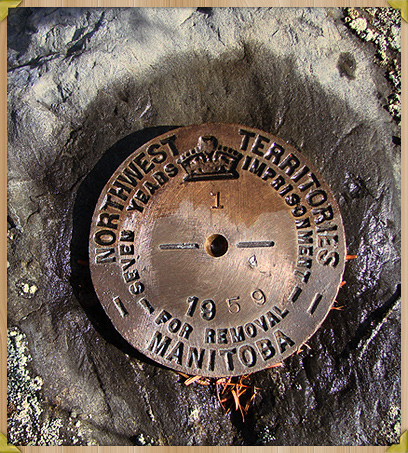
This image shows 1959 and 7 years in jail. I emailed the lodge to see if they can send us an image of the top of the marker. I assume the 59 was stamped in at time of placement so 1962 and five years in jail would be wrong in the article. 1962 may have been the estimated completion time of the project and they had all the obelisks stamped with that.--Canoe1967 (talk) 11:30, 20 May 2013 (UTC)
- What an interesting photo. The "five years" comes from a rather bloggy source (and I guess it could be wrong) but it claims to quote exactly what is inscribed on the obelisk itself including "1962" and the photo of the obelisk confirms 1962.[12][13] The article strictly does not say the obelisk was erected in 1962 but says it is "inscribed to say it was erected in 1962". I remember writing that bit,[14] knowing that pedants would be scrutinising every key press for OR. The new photo you have uploaded indicates Manitoba on one side and NWT on the other (which by my OR suggests Nunavut now). I think the legend could be re-written "A 1959 survey marker indicating the boundary of Manitoba and Northwest Territories near Hasbala Lake." Thincat (talk) 19:53, 20 May 2013 (UTC)
![[13]](https://en.wikipedia.org/wiki/File:4_Corners,_Canada,_Obelisk.jpg)
The title of this article and the lead[edit]
I would be happy to rename the article "four corners" or "Four corners" (including the quotes in the title) since that seems to be the common name, probably with (Canada) appended to disambiguate from Four Corners. My reasoning is that that is what the several sources seem to call the place.
In many ways I'd be happier if the lead, instead of saying "where four political subdivisions hypothetically meet" said "where four political subdivisions come close together or meet" except no-one seems to have found a source saying anything like that. The sources seem to say (possibly wrongly) that the boundaries cross. The article should not be (and isn't) claiming a precise quadripoint (or that it is not one). Do we know if this particular location on the NU-NWT boundary has been surveyed yet? If not, and from what I understand from earlier discussion the 102° is something of a guideline, until the surveyors have reported we cannot know the situation. If this part of the survey is complete, it is a great pity none of us seem to know the result. Of course, piecing together the various evidence seems to show no exact crossing but without a reliable source reaching that conclusion, we may not claim it in the article.
Finally I have just noticed that, back in 2009, material was copied from here[15] to quadripoint hence the admonition near the top of this talk page. Thincat (talk) 21:30, 20 May 2013 (UTC)
- As far as I can tell via googling, the NWT-NU boundary surveys so far have concentrated on areas near settlements and those near mineral claims. Pfly (talk) 10:13, 21 May 2013 (UTC)
- Must not be very much surveyed then.......well, the diamond claims get pretty extensive I guess......no diamonds near the 60th Parallel and the SK/MB boundary yet, but if it comes down to NT/NU/SK/MB squabbling over whose jurisdiction gets royalties, it'll get surveyed and darned fast LOL.Skookum1 (talk) 02:25, 22 May 2013 (UTC)
Since some believe that the title is original research, I was thinking something like the "Borders of Manitoba, Saskatchewan, Northwest Territories, and Nunavut", or "Intersection of the Manitoba, Saskatchewan, Northwest Territories, and Nunavut borders". But that's a long title. 117Avenue (talk) 03:07, 22 May 2013 (UTC)
- I am okay with "four corners" with quotes and no caps. Are we sure that we didn't create the label though? Some RS use this term but may have taken it from us. We could still join the four surveyor forums that I brought up in the AfD. We could let them neverendum it and then get back to us. They would be the world experts on it I assume. They may have valuable input to improve the article as well.--Canoe1967 (talk) 06:24, 22 May 2013 (UTC)
- The title should be Four corners (Canada), without quotes. Four Corners is not the proper name for this place, so we should use a descriptive name. There are four corners (whether they all meet at the same point or not...), so it is an accurate description, and it reflects the obvious parallel with the Four Corners in the US (which is a proper name). Per WP:TITLEFORMAT we should not use quotes or a capital C, but the initial F should be a capital. Bazonka (talk) 21:28, 22 May 2013 (UTC)
- Having started this bit of the discussion I forgot all about it but I am happy with the result. It hadn't actually occurred to me that there are four corners whether or not they all come together! As for the initial capital letter that is WP's way of doing titles except under highly unusual circumstances. I think the geometrical uncertainty adds to the interest but that is a matter strictly for the talk page. Thincat (talk) 19:56, 12 June 2013 (UTC)
Distance[edit]
I made File:Geodatata for Sask Man NWT and Nan.png and pixel counting in GIMP works out to 386.5m. Do we have an accurate number for what it should be?--Canoe1967 (talk) 21:53, 24 May 2013 (UTC)
- That's close to the "about 400 m" I calculated some years back. I got that number by dropping the two coordinates (60°00'N 102°00'W and 59°59′57.98511″N 102°00′27.24027″W) into some online distance calculator, perhaps the measure tool in Google Earth. Your map is interesting, but I'm not sure about its ultimate accuracy. It comes from OpenStreetMap, yes? OSM is a Wikipedia-like source, in which anyone can make edits. I haven't used it in a long time but have an editing account, so I went in and tried to determine who entered those boundaries and what their source was. I'm not very good with OSM, but it seems that all the boundaries in that area say their source is "geobase", meaning, I assume, GeoBase (geospatial data). As our article on GeoBase says, when it comes to geopolitical boundaries, "This data layer contains the international, inter-provincial, and territorial boundaries, as well as the boundaries of Canada’s exclusive economic zone. It is not intended for legal use, and should be utilized for cartographic purposes only." And, for what it's worth, neither of the coordinates on your OSM map are the same as those given by Natural Resources Canada, CSRS Online Database, station number 674002 (MON 157) (Established by : Legal Survey Of Canada - Nrcan), which I just checked again (register/login here [16]) and got the same coordinates already on our page here: N59° 59' 57.98511", W102° 00' 27.24027" (NAD83). To convert between decimal and DMS coordinates I use [17], which for the survey monument gives 59.99944,-102.007567. Inputing the CSRS coordinate and 60.0N102.0W into [18] gives 424.9870362099465 m. All that said, "about 400 m" seems good to me! Pfly (talk) 04:44, 25 May 2013 (UTC)
- Also, for what it's worth, the high-res topo maps of Canada (NRCan made) appear to still be available online via "mytopo.com", this link [19] should show the MT-SK-NWT "tripoint" marked with a survey monument symbol and the number "157". There are no topo maps at this scale just to the east, including where the NU-NWT boundary is shown on smaller scale ("lower res") topo maps. I'm not sure why that is. The topo cutoff is marked "District of Mackenzie", a pre-Nunavut name whose boundary was along 102°00'W, although never surveyed on the ground. It seems the District of Mackenzie/Nunavut was never mapped with topo maps at this scale. Pfly (talk) 05:14, 25 May 2013 (UTC)
- If you go to the link I got the map image from there are more maps there that may help. That was the only CC-by one that we can license at commons though. My dad was a surveyor for highways. He said there should be a marker ever square mile in Canada. He may have only been talking about south of 60 though. Sites like http://www.waymarking.com/ seem to enjoy finding and posting pictures of them.--Canoe1967 (talk) 08:43, 25 May 2013 (UTC)
- Getting an exact distance is possible through converting the coordinates to UTM. The toolserver includes this function (59°59′57.98511″N 102°00′27.24027″W / 59.9994403083°N 102.0075667417°W, 60°00′00.00000″N 102°00′00.00001″W / 60.0000000000°N 102.0000000028°W). Simple Pythagorean theorem will tell you it is 427m. Topo maps do exist east of 102°, the topoquest link, also found through the toolserver, has them. However can only show one side of 102° at a time, because of how the National Topographic System divides its map sheets. 117Avenue (talk) 00:06, 26 May 2013 (UTC)
- If you go to the link I got the map image from there are more maps there that may help. That was the only CC-by one that we can license at commons though. My dad was a surveyor for highways. He said there should be a marker ever square mile in Canada. He may have only been talking about south of 60 though. Sites like http://www.waymarking.com/ seem to enjoy finding and posting pictures of them.--Canoe1967 (talk) 08:43, 25 May 2013 (UTC)
- Also, for what it's worth, the high-res topo maps of Canada (NRCan made) appear to still be available online via "mytopo.com", this link [19] should show the MT-SK-NWT "tripoint" marked with a survey monument symbol and the number "157". There are no topo maps at this scale just to the east, including where the NU-NWT boundary is shown on smaller scale ("lower res") topo maps. I'm not sure why that is. The topo cutoff is marked "District of Mackenzie", a pre-Nunavut name whose boundary was along 102°00'W, although never surveyed on the ground. It seems the District of Mackenzie/Nunavut was never mapped with topo maps at this scale. Pfly (talk) 05:14, 25 May 2013 (UTC)
Do we know where the two Survey markers are on my map? Readers may wish to know where the two markers are in relation to 102°, 60°, and the actual two border lines. If the one is damaged then the government may pop up and fix it if I complain through email that 'Borders are very important and this marker should be verified as accurate or someone could lose an eye.' If we suck up the minister they may even take some photos for us. My lightest camera is still to heavy for Kite aerial photography or I would take a trip up and try some shots myself.--Canoe1967 (talk) 16:37, 26 May 2013 (UTC)
- Huh? Have you not read the article? An obelisk marks the point where the Manitoba–Saskatchewan border meets the Northwest Territories, at 59°59′57.98511″N 102°00′27.24027″W (NAD83), 427m west of 60°N 102°W. The Northwest Territories–Nunavut border is unmarked, and is either at 102°W or 102°00′27.24″W. 117Avenue (talk) 04:56, 28 May 2013 (UTC)
- I am just wondering where our 4 - 6 points are in relation to each other. We have legal borders that don't match 102/60, we have two markers that were placed, and we have true 102/60. I assume that the markers are at the legal border limits. Is the N/S marker precisely on 60 and where is it E/W? There should be a government account of where it was last found which may vary slightly from where they thought it was when it was placed. If we can find at least these two points then we should be able to create a diagram from the data. 102/60 we don't really need from OSM since it is simple trig. We just need to place our two markers as last found in relation to those two trig lines. This will give the readers some nice eye candy so they can actually 'see' where they are. Without the last surveyed locations of two more markers we shouldn't draw the legal borders in though.--Canoe1967 (talk) 16:27, 28 May 2013 (UTC)
- I don't understand what you mean by "we have two markers that were placed". There is the obelisk at N59° 59' 57.98511", W102° 00' 27.24027" (NAD83), placed before the creation of Nunavut and marking the tripoint of Manitoba, Saskatchewan, and NWT. What other marker is of concern? Pfly (talk) 22:57, 28 May 2013 (UTC)
- The N/S only one not far from it. See the image in the article?--Canoe1967 (talk) 23:05, 28 May 2013 (UTC)
- Considering you are the one who uploaded it, wouldn't you be the one to know? 117Avenue (talk) 04:54, 29 May 2013 (UTC)
- Canoe1967, do you mean the picture of the disc, "marking Manitoba's north border, east of the obelisk"? I'm not even sure why that picture is on this page. There are hundreds of survey markers along the provincial boundaries. Is that one special? I can get its coordinates from the CSRS Online Database if you'd like, although even if it is closer to 60°00'N 102°00'W I'm not sure how it would matter... Pfly (talk) 08:04, 29 May 2013 (UTC)
- But, in case it does matter and I'm confused, the next survey marker along Manitoba's northern boundary, east of the tripoint obelisk, is, according to Natural Resources Canada, CSRS Online Database, station number 674004 (MON 1) (Established by : Legal Survey Of Canada - Nrcan), N59° 59' 58.01195", W101° 59' 49.04294" (NAD83). Thus 179.895 metres from 60°00'N 102°00'W. So, closer to 60-102 than the tripoint obelisk. Maybe that is what you were getting at? If NRCan decides to use 60N,102W they will end up making a new tripoint located a bit closer to the disc marker than the obelisk (and slightly south of 60.0 N, presumably)—which would also mean there is no true quadripoint or "four corners". Of course if they decide to use the existing tripoint obelisk, making a true quadripoint, then the disc marker is irrelevent, right? Pfly (talk) 08:40, 29 May 2013 (UTC)
- Considering you are the one who uploaded it, wouldn't you be the one to know? 117Avenue (talk) 04:54, 29 May 2013 (UTC)
- The N/S only one not far from it. See the image in the article?--Canoe1967 (talk) 23:05, 28 May 2013 (UTC)
- I don't understand what you mean by "we have two markers that were placed". There is the obelisk at N59° 59' 57.98511", W102° 00' 27.24027" (NAD83), placed before the creation of Nunavut and marking the tripoint of Manitoba, Saskatchewan, and NWT. What other marker is of concern? Pfly (talk) 22:57, 28 May 2013 (UTC)
- I am just wondering where our 4 - 6 points are in relation to each other. We have legal borders that don't match 102/60, we have two markers that were placed, and we have true 102/60. I assume that the markers are at the legal border limits. Is the N/S marker precisely on 60 and where is it E/W? There should be a government account of where it was last found which may vary slightly from where they thought it was when it was placed. If we can find at least these two points then we should be able to create a diagram from the data. 102/60 we don't really need from OSM since it is simple trig. We just need to place our two markers as last found in relation to those two trig lines. This will give the readers some nice eye candy so they can actually 'see' where they are. Without the last surveyed locations of two more markers we shouldn't draw the legal borders in though.--Canoe1967 (talk) 16:27, 28 May 2013 (UTC)
The lodge owner that sent me the other images said that one is near the obelisk. I am not sure if is exactly on 60, in 1959 they didn't have GPS so it is doubtful that it is. I don't think he has sent permissions to OTRS so the other shots may be deleted if he has changed his mind about licencing them. He should be back up there by now and was willing to take a picture of the top of the obelisk disk for us. I may yet email the government survey ministry and see if they can provide images and more info on how they plan to survey. Eventually they may decide on a true quadripoint and then we can discuss the article title again. There is a way to lower case the F in four that we may yet decide to do.--Canoe1967 (talk) 20:35, 12 June 2013 (UTC)
- We should not change the F to lower case. The initial character of an article name should only be lower case in the special situations where the name always starts lower case - and this only really applies to companies and band names etc., for example k.d. lang and eBay. "Four corners" would have a capital F if it is used at the start of a sentence. Bazonka (talk) 16:44, 19 July 2013 (UTC)
New images[edit]
I uploaded pics of the top of the obelisk, since that seemed of interest.. I have many more pics of the area if needed..sorry if I posted this in the wrong spot since I'm still a little newbie to wikipedia..:) http://commons.wikimedia.org/wiki/File:Disk_on_top_of_Obelisk_at_4_Corners_Canada_1.JPG http://commons.wikimedia.org/wiki/File:Disk_on_top_of_Obelisk_at_4_Corners_Canada_2.JPG — Preceding unsigned comment added by Mlugassy (talk • contribs) 06:21, 19 July 2013 (UTC)
- Thanks for the pictures. It is fine to post here on the talk page. I will get them in the category over at commons.--Canoe1967 (talk) 06:33, 19 July 2013 (UTC)
Corners/quadripoint[edit]
I don't like the revisions that Jkshapiro has made. Removing "four corners meet" and "four corners are located", and adding "potential four corners", "If it does, then this creates a Canadian four corners", and "potential four corners". I think Jkshapiro has confused "four corners" with quadripoint. There is no question there are four corners, Manitoba, Saskatchewan, Northwest Territories, and Nunavut (four) all have corners; this fact is what kept the article at the four corners name. What is unclear is if there is a quadripoint. Quadripoint is what should be described as "might" and "potential". Jkshapiro's current sentence with the bolded article title name, "If it does, then this creates a Canadian four corners", implies that the name of this article is original research, which has been disputed in the past. 117Avenue (talk) 04:13, 23 May 2015 (UTC)
- If this article is not about a quadripoint then it requires significant rewriting and some new sources. The cited sources all interpret "four corners" as a place where four administrative divisions meet. Jkshapiro (talk) 04:35, 29 May 2015 (UTC)
- I'm sorry, I don't follow. I don't think you have argued against my points at all. Where are you seeing a definition for "four corners"? Since I believe that you have not provided good reasoning for your changes, I encourage you to explain your position more, and I will be reverting you in the spirit of WP:BRD. 117Avenue (talk) 03:31, 1 June 2015 (UTC)
- There are a few issues here. Let's take them individually.
- 1. What does "four corners" mean?
- In my opinion, this term is inextricably linked to the American Four Corners and must refer to a quadripoint if it has any meaning at all. But I'm no more the owner of this article than you are, so let's look at the sources quoted in the article.
- Hill: "(This means Canada now has a 'four corners' point like the one where Arizona, Colorado, New Mexico, and Utah meet.)"
- Canada Tourism Development Corporation: "The creation of Nunavut created Canada's only 'four corners', at the intersection of the boundaries of Nunavut, the Northwest Territories, Manitoba, and Saskatchewan, at 60°00' north, 102°00' west, on the southern shore of Kasba Lake."
- Butler: "The boundary junction of Manitoba, Northwest Territories, Nunavut, and Saskatchewan is marked by a meter high aluminum obelisk."
- All of these are referring to a single point where four regions meet.
- 2. Is there a quadripoint?
- We know that this is indeterminate. The law provides two contradictory definitions of the Nunavut/NWT border. Therefore the borders don't "hypothetically" or "theoretically" meet; rather they "potentially" or "might" meet, depending on whether the surveyors decide to connect that border with the Manitoba/Saskatchewan border.
- 3. Do the provided sources support the thesis of the article?
- Not really. As noted above, they claim there is a quadripoint, full stop. If we want to avoid original research then that's where this article needs to stop too. My rewrites didn't go that way, because I think it's a disservice to the truth, but the current wording doesn't do that either.
- 4. Are the provided sources high quality?
- Hill gives one brief parenthetical remark in a book on a different subject, and the other two are tourism websites. I would love to find a source more fitting to serve as the source for an encyclopedia article; I suspect the reason we can't find one is because the place under discussion is not known to be a quadripoint so there's nothing to say.
- 5. Is the article written clearly and in the style of an encyclopedia?
- It could use some help. That's why I made three separate edits: the first two were simply to clean up the wording without changing the meaning of the article; the third was the one where I tried to highlight the essential ambiguity around the very existence of this quadripoint. By reverting the first two edits along with the third, you're throwing the baby out with the bathwater.
- That is the reasoning for my changes. I hope you and the other editors find it "good". Jkshapiro (talk) 03:04, 3 June 2015 (UTC)
- Sorry if I've sounded rude about this, I've only been going by memory. I was hoping the users involved in the move discussion would be involved with this discussion as well. But it looks like there was only a handful, and the vocal one is currently blocked. Both sources put four corners in quotation marks. I think they don't know the term quadripoint, and are using four corners for lack of a better term. I agree the term is drawing from the American Four Corners, but I thought that removing the capital C, and with the lead saying "the four corners of Canadian subdivisions meet", would give "four corners" a different meaning. Does quadripoint provide good references for its definition? I now realize that we discussed before about the terms "theoretically" and "potentially". I think this depends on if the decision has been made or not. If the decision on the quadripoint has been made, and we aren't aware of it, it is theoretically a quadripoint. If a surveyor has yet to make the decision, it is potentially a quadripoint until that time. I've read your first two edits again, and agree that it does help with grammar, and flow of the article. However, if I could be nitpicky, is there still a place for "extremely remote and inaccessible", and "the pre-existing boundary of Saskatchewan and Manitoba, as surveyed, does not fall precisely on the meridian"? 117Avenue (talk) 05:14, 4 June 2015 (UTC)
- I'm sorry, I don't follow. I don't think you have argued against my points at all. Where are you seeing a definition for "four corners"? Since I believe that you have not provided good reasoning for your changes, I encourage you to explain your position more, and I will be reverting you in the spirit of WP:BRD. 117Avenue (talk) 03:31, 1 June 2015 (UTC)
External links modified[edit]
Hello fellow Wikipedians,
I have just modified one external link on Four corners (Canada). Please take a moment to review my edit. If you have any questions, or need the bot to ignore the links, or the page altogether, please visit this simple FaQ for additional information. I made the following changes:
- Added archive https://web.archive.org/web/20051228112441/http://www.canlii.org:80/ to http://www.canlii.org/
When you have finished reviewing my changes, you may follow the instructions on the template below to fix any issues with the URLs.
This message was posted before February 2018. After February 2018, "External links modified" talk page sections are no longer generated or monitored by InternetArchiveBot. No special action is required regarding these talk page notices, other than regular verification using the archive tool instructions below. Editors have permission to delete these "External links modified" talk page sections if they want to de-clutter talk pages, but see the RfC before doing mass systematic removals. This message is updated dynamically through the template {{source check}} (last update: 18 January 2022).
- If you have discovered URLs which were erroneously considered dead by the bot, you can report them with this tool.
- If you found an error with any archives or the URLs themselves, you can fix them with this tool.
Cheers.—InternetArchiveBot (Report bug) 16:02, 3 January 2017 (UTC)
External links modified[edit]
Hello fellow Wikipedians,
I have just modified 2 external links on Four corners (Canada). Please take a moment to review my edit. If you have any questions, or need the bot to ignore the links, or the page altogether, please visit this simple FaQ for additional information. I made the following changes:
- Corrected formatting/usage for http://www.canlii.org///ca/sta/n-28.6/part297109.html
- Added archive https://web.archive.org/web/20130429214946/http://aptn.ca/pages/news/2011/06/28/nwt-nunavut-border-under-the-microscope/ to http://aptn.ca/pages/news/2011/06/28/nwt-nunavut-border-under-the-microscope/
When you have finished reviewing my changes, you may follow the instructions on the template below to fix any issues with the URLs.
This message was posted before February 2018. After February 2018, "External links modified" talk page sections are no longer generated or monitored by InternetArchiveBot. No special action is required regarding these talk page notices, other than regular verification using the archive tool instructions below. Editors have permission to delete these "External links modified" talk page sections if they want to de-clutter talk pages, but see the RfC before doing mass systematic removals. This message is updated dynamically through the template {{source check}} (last update: 18 January 2022).
- If you have discovered URLs which were erroneously considered dead by the bot, you can report them with this tool.
- If you found an error with any archives or the URLs themselves, you can fix them with this tool.
Cheers.—InternetArchiveBot (Report bug) 23:42, 4 October 2017 (UTC)
surveys, maps, mining districts, etc[edit]
Sorry if this post is longer than the article itself. Sorry if some of it is a repeat of what has been said above.
I have provided links to field notes and reports for several surveys. Each of these links points to a details page. Each details page provides a link to one PDF file. The PDF files are all high resolution scans of original survey documents; all of the files are large.
1871: commencement of Dominion Lands Survey[edit]
- The Second Meridian of the Dominion Land Survey was defined as being 102°W. [1]
1905 Saskatchewan borders defined[edit]
- The northeast corner of Saskatchewan was defined as he intersection of the Second Meridian in the system of Dominion lands surveys and 60°N.
- The exact location of the northeast corner was not surveyed or marked on the ground.
1912: Manitoba extended to 60°N[edit]
- Manitoba was extended north such that its northwest corner coincided with the northeast corner of Saskatchewan.
- This effectively formed a tripoint where the boundaries of Northwest Territories, Saskatchewan, and Manitoba all met.
- The exact location of the tripoint remained unsurveyed and unmarked.
1962: SK/MB boundary survey[edit]
- The last and most northerly section of the SK/MB boundary was surveyed between January and April of 1962. [2][3]
- The survey crew installed 85 survey monuments (#73 - #157) as they worked their way north along the Second Meridian to the NWT border.
- The entire line (including parts surveyed in the previous winter) runs about 27 arcseconds west of 102°W(NAD83) or about 25 arcseconds west of 102°W(NAD27).
- On April 6,1962 the survey crew installed its final survey monument (#157) at the NWT border; this officially marked the location the NWT,SK,MB tripoint.
- Unlike other simple monument markers along the border, Monument 157 was (and still is) a 30 inch tall Aluminum obelisk; it was bolted to a 8 foot galvanized pipe which was buried 6 feet into the ground.
I feel compelled to include here an irrelevant snippet from the survey report:
1967: reinstallation of Monument 157[edit]
- Over the next few years, Monument 157 became disturbed by frost action. Photos show that the pipe had pushed about two feet out of the ground. In May of 1967 the monument was temporarily removed so that a new concrete pad could be laid. On June 7,1967 the monument was affixed to the new pad.[4]
1993: NT/NU boundary defined[edit]
From the 1993 Nunavut Act: [5]
It is impossible to interpret any legal or inferred meaning from this legal text for two reasons:
- The act does not specify the the datum for which to interpret the coordinates; i.e. the act does not state whether to use NAD27, NAD83, or WGS84.
- The intersection of the NWT, SK, and MB borders is not (and never has been) located at 60°00′N 102°00′W regardless of which datum one decides to use.
Cartographers were forced to guess where the boundary is supposed to be. This led to much inconsistency between maps; nobody could claim any map was right or wrong.
1994: alternate use of Monument 157[edit]
In addition to being a boundary marker, Monument 157 is also cataloged as a 2D passive control station in the Canadian Spatial Reference System (CSRS).[6]
Data is given as follows:
- Name: MON 157.
- Station ID: is 674002.
- Coordinates: 59°59′57.9851″N 102°0′27.2403″W(NAD83)
- Year of publication: "1994-01-01 00:00:00.0"
[edit]
- Nunavut became a territory on April 1, 1999.
2000: mining districts established[edit]
The federal government created formal definitions for the Northwest Territories Mining District and the Nunavut Mining District. [7]
Northwest Territories Mining District is defined as:
There is nothing in this definition that makes the boundaries of the Northwest Territories Mining District any different than the boundaries of the Northwest Territories.
Nunavut Mining District is defined as
(a) all that part of Canada north of the sixtieth parallel of north latitude and east of the western boundary of Nunavut described in Schedule I to the Nunavut Act that is not within Quebec or Newfoundland; and
(b) the islands in Hudson Bay, James Bay and Ungava Bay that are not within Manitoba, Ontario or Quebec.There is nothing in this definition that makes the boundaries of the Nunavut Mining District any different than the boundaries of the Nunavut.
2013: survey conducted 472km north of four corners[edit]
- In 2012 The Surveyor General Branch (SGB) of Natural Resources Canada contracted out a survey of 329km of boundary between the Northwest Territories Mining District and the Nunavut Mining District.
- This is the section that was legislated to run from 64°14′N 102°00′W to 64°50′N 109°20′W. It starts roughly 472km north of the four corners and heads WNW.
- The survey was completed in March 2013.
- The survey included the installation 36 new Canada Lands Survey monuments; the only one relevant to this four corners article is Monument 201 at 64°14′00.0000″N 102°00′00.0000″W(NAD27) [8] or 64°14′01.1902″N 102°00′02.1474″W / 64.233663944°N 102.000596500°W(NAD83).
2014: survey conducted at the four corners[edit]
- In 2014 The Surveyor General Branch (SGB) of Natural Resources Canada contracted out a survey of 472km of boundary between the Northwest Territories Mining District and the Nunavut Mining District.
- This is the section that is supposed to start somewhere in the vicinity of the four corners and head north to 64°14′N 102°00′W.
The Notice of Proposed Procurement is still online for viewing. [9] It contains the following blurb:
The Request for Proposal is also online.[10] It contains the following requirements:
- note: Monument 2-1 is the same as Monument 201.
- The survey was completed in September 2014.
- The survey crew demarcated the boundary with 48 new survey monuments that all lie in a 472km geodesic line between Monuments 157 and Monument 201. [11][12]
- The survey determined the location of Monument 157 to be 59°59′57.9689″N 102°00′27.1758″W / 59.999435806°N 102.007548833°W(NAD83). Maximum error on the survey is listed as being 5cm or better.
- The new monuments were all standard Canada Lands Survey (CLS) monuments.
- Each new monument cap was inscribed with the following names/words/numbers:
ARPENTAGE des TERRES
CANADA LANDS SURVEY
TERRITORIES DU NORD-OUEST
NORTHWEST TERRITORIES
2014
monument number
- The words "MINING" and "DISTRICT" do not appear on the survey monuments (not for this survey or for any of the surveys conducted along the mining district boundary).
- The surveyed line does not touch or intersect with 102°W(NAD83).
- The surveyed line does touch W102°(NAD27), but only at its northern termination point (Monument 201).
- The location of the surveyed line results in a quadripoint at Monument 157.
2016: SGB biennial review published[edit]
The Surveyor General Branch (SGB) 2014-2016 biennial report has this to say:[13]
The boundary between Nunavut and the Northwest Territories was established in 1999. It was defined in legislation but not demarcated on the ground, making it the longest un-surveyed boundary in Canada. This led to some uncertainty as to its location, particularly in regard to mining rights issued by each territory. Beginning in 2010, SGB-CLSS has administered and regulated the survey of the boundary. The surveyed boundary promises to be an essential tool for land governance because it will specify the exact NWT-NU boundary on both map and ground, ultimately preventing any conflicts that pertain to land. As boundary experts, SGB resolved three issues:
- Point of commencement. Map coordinates of the south corner did not correspond to a survey monument (at the Manitoba–Saskatchewan corner). The monument (No. 157) was accepted.
- The wording in that section of the report makes it clear that the SGB expects the newly surveyed boundary to ultimately be treated as the true boundary between the two territories even though we know it was conducted on the premise of being a mining district boundary.
- Mining rights are mentioned, but there is zero mention of mining districts or mining district boundaries.
- Note also that the boundary was not established in 1999 as the article states; it was established in 1993 but only became relevant in 1999 when Nunavut became a territory.
There is a footnote that reads:
2018: SGB biennial review published[edit]
The Surveyor General Branch (SGB) 2014-2016 biennial report has this to say: [14]
2021: New maps on Wikimedia Commons[edit]
- I have created a couple of "four corners" maps that show locations of both the surveyed boundary lines and the survey monuments.
- Just like the survey monument caps, the maps do not include the words "MINING" or "DISTRICT". No regrets.
- I have treated the surveyed NT/NU boundary as being the true territorial boundary even if it has not been officially sanctioned in legislation. I do not think there is a more reasonable option available.
MapGrid (talk) 04:33, 4 February 2021 (UTC)
- Well, thank you for this which I have read with fascination. That the boundary should matter so much! If I understand right the surveyors are (suggesting) making the NT/NU boundary start at the 157 marker but this only applies to mining areas pending legislative approval for the legal territory boundary. Thincat (talk) 12:41, 4 February 2021 (UTC)
- @Thincat: I think that in general you have drawn the same conclusions that I have. However, technically the surveyors are the people that got hired to demarcate the boundary; they just followed instructions from the SGB (Surveyor General Branch of the Ministry of Natural Resources). I realize that I am nitpicking by stating that, but it needs to be clear that the decision as to where to start the NT/NU boundary was strictly made by government as opposed to being made by a survey crew.
- Ultimately the federal government under the direction of the SGB forked out millions of dollars to have the entire NT/NU boundary demarcated with legal survey markers. This tell me that the surveyed boundary should probably be treated as more than just a suggestion... even if it has not yet been officially endorsed as a legal territorial boundary. MapGrid (talk) 14:38, 4 February 2021 (UTC)
- Yes, I understand now. This article was under some risk of deletion at one time and I think it needs to stay carefully referenced. The paragraph you added here has no reference at the end. Would [13] be sufficient? I also see the marker is located at an approximate elevation of 348 m[6] and this may be worth adding. Thincat (talk) 09:16, 5 February 2021 (UTC)
- @Thincat: I went ahead and reworded most of the article. I added the extra reference and the elevation. I also removed one or two references that did not appear to provide any relevant information. Now in all honesty, I far prefer cartography to writing. If you want to rewrite the whole thing and/or revert my last edit I won't be terribly upset.MapGrid (talk) 22:50, 5 February 2021 (UTC)
- Yes, I understand now. This article was under some risk of deletion at one time and I think it needs to stay carefully referenced. The paragraph you added here has no reference at the end. Would [13] be sufficient? I also see the marker is located at an approximate elevation of 348 m[6] and this may be worth adding. Thincat (talk) 09:16, 5 February 2021 (UTC)
References
- ^ "The Canadian Prairie Dominion Land Survey". The Dominion Land Survey. Retrieved 28 January 2021.
- ^ Boutiler (1962). "MONUMENTS # 72 TO THE 60TH PARALLEL (eng; CAN)" (pdf). Canada Lands Surveys. Retrieved 27 January 2021.
- ^ Boutiler (1962). "MON. 72 TO THE 60TH PARALLEL WINTER DIARY (eng; CAN)" (pdf). Canada Lands Surveys. Retrieved 27 January 2021.
- ^ Selley (1967). "REPLACEMENT OF MON. 157, MAN/SASK/NWT BOUNDARY (eng; CAN)" (pdf). Canada Lands Surveys. Retrieved 27 January 2021.
- ^ "SCHEDULE I (Section 3) Western Boundary of Nunavut". Justice Laws Website. Government of Canada. 1993. Retrieved 28 January 2021.
- ^ a b "Station Report". Retrieved 27 January 2021.
- ^ "Northwest Territories Mining District and Nunavut Mining District Order (SI/2000-53)". Justice Laws Website. Government of Canada. 2000. Retrieved 28 January 2021.
- ^ Ollerhead (2013). "FIELD NOTES OF SURVEY OF 329 KILOMETRES OF ARTIFICIAL BOUNDARIES ON CANADA LANDS BETWEEN NORTHWEST TERRITORIES AND NUNAVUT MINING DISTRICTS QUADS 66 D/1, 66 D/5, 66 D/6, 66 D/7, 66 D/8, 66 C/4, 76 A/7, 76 A/8, 76 A/10, 76 A/11, 76 A/12, 76 B/9, 76 B/10, 76 B/11, 76 B/12, 76 B13, 76 C/9, 76 C/10, 76 C/15, 76 C/16 NORTHWEST TERRITORIES/ NUNAVUT (eng; CAN)" (pdf). Canada Lands Surveys. Retrieved 27 January 2021.
- ^ "Legal Survey (23428-150107/A)". Buyandsell.gc.ca. Government of Canada. 2014. Retrieved 28 January 2021.
- ^ "REQUEST FOR PROPOSAL - Legal survey" (PDF). Buyandsell.gc.ca. Government of Canada. Retrieved 28 January 2021.
- ^ Stevens (2014). "FIELD NOTES OF SURVEY OF 472 KILOMETRES OF ARTIFICIAL BOUNDARIES ON CANADA LANDS BETWEEN NORTHWEST TERRITORIES AND NUNAVUT MINING DISTRICTS, QUADS 64 M/16, 65 D/01, 65 D/08, 65 D/09, 65 D/16, 65 E/01, 65 E/08, 65 E/09, 65 E/16, 65 L/01, 65 L/08, 65 L/09, 65 L/16, 65 M/01, 65 M/08, 65 M/09, 65 M/16 AND 66 D/01, 2 SHEETS (eng; CAN)" (pdf). Canada Lands Surveys. Retrieved 28 January 2021.
- ^ Stevens (2014). "SURVEY REPORT FOR FIELD NOTES OF SURVEY OF 472 KILOMETRES OF ADMINISTRATIVE BOUNDARY BETWEEN NUNAVUT AND NORTHWEST TERRITORIES MINING DISTRICSTS (eng; CAN)" (pdf). Canada Lands Surveys. Retrieved 28 January 2021.
- ^ a b "Canada's Boundaries and Geodetic Foundation: Surveyor General Branch Biennial Review 2014–2016" (PDF). Canada Lands Surveys. Government of Canada. 2016. p. 6. Retrieved 28 January 2021.
- ^ "Surveyor General Branch Biennial Report 2016–2018" (PDF). Canada Lands Surveys. Government of Canada. 2018. p. 8. Retrieved 29 January 2021.
- Start-Class Canada-related articles
- Low-importance Canada-related articles
- Start-Class Manitoba articles
- Low-importance Manitoba articles
- Start-Class Saskatchewan articles
- Low-importance Saskatchewan articles
- Start-Class Canadian Territories articles
- Low-importance Canadian Territories articles
- Start-Class Geography of Canada articles
- Low-importance Geography of Canada articles
- All WikiProject Canada pages