
Talk:Cape York Peninsula
| This is the talk page for discussing improvements to the Cape York Peninsula article. This is not a forum for general discussion of the article's subject. |
Article policies
|
| Find sources: Google (books · news · scholar · free images · WP refs) · FENS · JSTOR · TWL |
| This It is of interest to the following WikiProjects: |
||||||||||||||||||||
| ||||||||||||||||||||


CAPE YORK PENINSULA[edit]
Latitude and Longitude The latitude and longitude of the Cape York Peninsula is 27°28′S and 153°02′E. It is located at the tip of Queensland. Since it is located near the equator, it receives a tropical climate.
Climate The climate in Cape York Peninsula is divided into a wet and a dry season. The temperature across it is warm to hot, with a cooler climate in higher areas. The mean annual temperatures range from 18oC at higher elevations to 270C on the lowlands in the far south-west. A temperature over 40oC in the summer and below 5oC is rare.
Landforms There are many types of landforms in the Peninsula, ranging from mountains found on the east coast, foothills and lowlands surrounding it to the west.
Notes[edit]
Thanks for the information above, but I must mention that you cannot give latitude and longitude for the whole penninsula as it covers a huge area. I have, however, just added the coordinates for the tip of Cape York. I have added in the information you gave on climate and landforms with some small changes. I hope you aprove. John Hill 01:48, 23 July 2006 (UTC)
- There's evidence to suggest wild pigs are actually native to Cape York, having migrated from New Guinea. 49.177.208.149 (talk) 00:32, 24 March 2023 (UTC)
Article overhaul[edit]
Hello there, I have recently done some research on Cape York Peninsula und though I could share my insights here. As I see the current entry is classified only as a Start-class article and could do with some more information and a better structure. Is anyone monitoring this site and if yes, would it be alright to just edit the whole page, keeping some of the exisiting information and adding a whole lot more? I'm new to Wikipedia so I'm not sure whether that is acceptable. What I've got is mainly on the natural environment, but includes a lot of useful references that I are not included in the entry so far. Hope to hear from someone soon, otherwise I will just post my proposal and see what happens. —Preceding unsigned comment added by Jensemilla (talk • contribs) 04:44, 23 April 2008 (UTC)
- Go for it. So long as what you add is your own work, and not copied from somewhere else, then you are free to contribute. Oh, and you have to be willing to see your work get edited mercilessly by others. Hesperian 04:56, 23 April 2008 (UTC)
- I second that and will try to help when I can - though I will be away travelling from mid-May to mid-July. Best wishes, John Hill (talk) 11:15, 23 April 2008 (UTC)
- So I've just put up my edits. Thanks especially Hesperian for your info on how to start. Good stuff, I think I will be around here again.--Jensemilla (talk) 01:45, 2 May 2008 (UTC)
- Outstanding content. Really, it's extraordinary for someone to do such a thorough rewrite on their first real edit. I'll fix a few stylistic things e.g. we don't leave "this needs editing" comments. Hesperian 01:56, 2 May 2008 (UTC)
- Cool. So the sections that still need editing are better left out and then someone can add it at a later time? I just thought that it would be useful to indicate what still needs to be covered to make it more complete. But thanks for fixing up the article for now. See you around here later on--Jensemilla (talk) 02:28, 2 May 2008 (UTC)
Biogeography[edit]
One of the IBRA regions is named "Cape York Peninsula"; there's a map here and a biodiversity assessment here. The World Wildlife Fund terrestrial ecoregion named Cape York Peninsula tropical savanna coincides with the IBRA region,[1] as does the BirdLife International Endemic Bird Area named "Cape York".[2] Hesperian 02:06, 2 May 2008 (UTC)
Why is it so sparsely populated?[edit]
I can't find the answer —Preceding unsigned comment added by 75.170.187.124 (talk) 06:32, 16 March 2010 (UTC)
- This is due to several reasons, including: most of the land is only marginally suited for agriculture due to poor quality tropical soils; it is a long way from any markets; the roads tend to be poor; and there are no good harbours. Hope this is some help. Cheers, John Hill (talk) 17:16, 7 June 2010 (UTC)
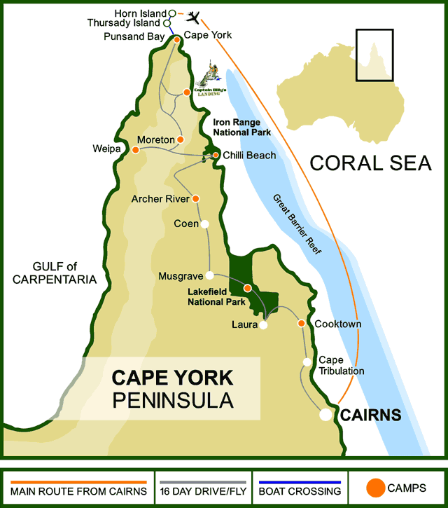
The new map[edit]
I am pleased to see the addition of a new map but wonder if someone could improve it by changing the heading to Cape York Peninsula (as Cape York technically only refers to the cape at the tip of the peninsula)? It would also be helpful if more details could be added, including the main Aboriginal communities, and some of the main landforms and rivers. Many thanks. John Hill (talk) 17:20, 7 June 2010 (UTC)
- John Hill is absolutely correct, except he needs to remove "technically". The title of the map is simply wrong. It needs to go. Here is a map that can help editors understand: http://nikonites.com/attachments/general-photography/121621d1414891090-cape-york-adventure-august-2015-a-map_section5.gif The left image is Australia. The middle image is Cape York Peninsula (the peninsula that leads to and is named for Cape York). The third image is the top end of the Peninsula, culminating in Cape York, basically from Bamaga northward. It's a great pity that the incorrectly titled map has stayed on the article for almost 5 years since John Hill pointed out it is wrong. "Pij" (talk) 13:54, 20 March 2015 (UTC)
This image may help editors understand what Cape York is."Pij" (talk) 15:21, 20 March 2015 (UTC)
Onthe other hand, this one may help editors understand what and where the Peninsula is. This article is supposed to be about the Peninsula, not the Cape."Pij" (talk) 15:29, 20 March 2015 (UTC)
- The map question has been addressed by inserting a new one altogether. Summerdrought (talk) 01:03, 8 April 2017 (UTC)
- Much better, Summerdrought. This is clear, correctly titled and labelled, and shows relationship to Australian continent.
The whole peninsula?[edit]
I find both the content of the article and the map to be limited to barely more than the northern half of Cape York Peninsula. The flat and featureless landscape described is only part of the story. If we run a line due east from the southernmost point of the Gulf of Carpentaria, it passes south of Normanton, Ravenshoe and Innisfail. The whole of the Peninsula thus includes the city of Cairns, the highest mountains in Queensland, the fertile Atherton Tableland and coastal sugar-growing areas, and historic mineral fields such as the Palmer goldfield and the Chillagoe and Herberton districts. That's a much bigger story. Peter Bell (talk) 22:59, 24 February 2011 (UTC)
- Hi Peter: In the technical sense of the definition of a Peninsula, you are correct. But general usage of the Term CApe York Peninsula (CYP) usually refers the approximate area of the lands to the north of the Bloomfield River on the east coast and the Kowanyama River on the west or (as it says in the article: "There is no clear demarcation to the south, although the official boundary in the Cape York Peninsula Heritage Act 2007 of Queensland runs along approximately 16°S latitude.").
- There are several reasons why this is so - until the 1960s there was no road at all up the Peninsula, then for years there was a very rough dirt road only (and still is once you get past Cooktown) and there is a large expanse of mainly empty bushlands before reaching any of the communities on the Peninsula - Cooktown and Weipa being the only ones of any size, and they are both small. Also, the landscape changes radically after leaving the region of Mt. Molloy and Mt. Carbine and driving north. Finally, because of the isolation, there are cultural differences, with locals seeing themselves as leading very different lifestyles than people in the more populated areas to the south. Hope this explains the way the name is used in this article. Sincerely, John Hill (talk) 04:49, 25 February 2011 (UTC)
- Thanks, John, I can follow that reasoning. Perhaps that could be spelled out a bit more clearly in the article. I grew up in Cairns, where people believe they live on CYP, and on reading the article I thought, "Hey, this leaves out half the Peninsula!" But I agree the country certainly changes dramatically once you drive north from Laura. Peter Bell (talk) 07:17, 25 February 2011 (UTC)
Cape York Telegraph Track[edit]
I can find very little mention of this track. I could add a section about this. Maybe a little about it's route and history and current day's usage.125.255.112.78 (talk) 06:36, 12 June 2011 (UTC)
- A new section titled 'Telegraph Track' was added by IP 124.186.84.222 on 13 June 2011. Unfortunately it appears to be copied directly from a tour guide's notes, contains numerous spelling errors, and is not suitable WP style. The same IP address had added external links directly to a commercial tour operator on this page and the Simpson desert article, which were removed as per WP:NOTADVERTISING. If the new section is not re-written, I recommend its removal. Any comments please? Summerdrought (talk) 21:28, 13 June 2011 (UTC)
The bigger picture[edit]
Inclusion of a map that shows the whole of Australia and the peninsula's place within it would be a good idea, and is kind of standard too. Carlwev (talk) 12:35, 10 June 2012 (UTC)
- Done Summerdrought (talk) 23:45, 31 January 2017 (UTC)
Sand dunes around Cape Flattery[edit]
The picture captioned "Sand dunes around Cape Flattery" looks oddly like a picture of steep snow-covered hills (the sort found near Cape Flattery USA). Can anyone confirm that Cape Flattery Australia really looks like this? Peter Gulutzan (talk) 03:25, 24 August 2012 (UTC)
- The photo is Cape Flattery in Australia, confirmed by personal observation.Summerdrought (talk) 21:43, 12 August 2014 (UTC)
External links modified[edit]
Hello fellow Wikipedians,
I have just modified 7 external links on Cape York Peninsula. Please take a moment to review my edit. If you have any questions, or need the bot to ignore the links, or the page altogether, please visit this simple FaQ for additional information. I made the following changes:
- Added archive https://web.archive.org/web/20080627115500/http://www.epa.qld.gov.au/register/p00582aj.pdf to http://www.epa.qld.gov.au/register/p00582aj.pdf
- Added archive https://web.archive.org/web/20080412023624/http://www.environment.gov.au:80/erin/cyplus/lup/index.html to http://www.environment.gov.au/erin/cyplus/lup/index.html
- Added archive https://web.archive.org/web/20080523143929/http://www.anra.gov.au:80/topics/vegetation/pubs/native_vegetation/nat_veg_contents.html to http://www.anra.gov.au/topics/vegetation/pubs/native_vegetation/nat_veg_contents.html
- Added archive https://web.archive.org/web/20080727111939/http://www.anra.gov.au/topics/rangelands/overview/qld/ibra-cyp.html to http://www.anra.gov.au/topics/rangelands/overview/qld/ibra-cyp.html
- Added archive https://web.archive.org/web/20080727111939/http://www.anra.gov.au/topics/rangelands/overview/qld/ibra-cyp.html to http://www.anra.gov.au/topics/rangelands/overview/qld/ibra-cyp.html
- Added archive https://web.archive.org/web/20080627115518/http://www.epa.qld.gov.au/publications/p02227aa.pdf/Compiling_a_case_for_World_Heritage_on_Cape_York_Peninsula_Final_report_for_QPWS_/_compiled_by_Peter_S_Valentine_James_Cook_University.pdf to http://www.epa.qld.gov.au/publications/p02227aa.pdf/Compiling_a_case_for_World_Heritage_on_Cape_York_Peninsula_Final_report_for_QPWS_/_compiled_by_Peter_S_Valentine_James_Cook_University.pdf
- Added archive https://web.archive.org/web/20080516190747/http://www.cypda.com.au:80/front_page to http://www.cypda.com.au/front_page
When you have finished reviewing my changes, please set the checked parameter below to true or failed to let others know (documentation at {{Sourcecheck}}).
This message was posted before February 2018. After February 2018, "External links modified" talk page sections are no longer generated or monitored by InternetArchiveBot. No special action is required regarding these talk page notices, other than regular verification using the archive tool instructions below. Editors have permission to delete these "External links modified" talk page sections if they want to de-clutter talk pages, but see the RfC before doing mass systematic removals. This message is updated dynamically through the template {{source check}} (last update: 18 January 2022).
- If you have discovered URLs which were erroneously considered dead by the bot, you can report them with this tool.
- If you found an error with any archives or the URLs themselves, you can fix them with this tool.
Cheers.—InternetArchiveBot (Report bug) 15:17, 14 November 2016 (UTC)
Massive area[edit]
The following is perhaps not encyclopedic, but adding info that the enormous area would correspond to a rectangle with sides 537.5 kilometres (334 miles) long (not 100% precise) would show in an easy way the scale of this massive area. Denmark, where I am from, is 368 km north south and 452 east west, and the land area of Denmark (proper) is approximately 368 times 1/3 of 368 (appr. 120)=44,160 square kilometres. Just a thought around noon Saturday. Well.. --Bornsommer (talk) 11:44, 17 November 2018 (UTC)
- Adding:the peninsula (=area almost surrounded by water) actually is from the bottom of the Gulf of Carpentaria and the east to a point well south of Cairns. That would make the actual area perhaps more than twice as big as mentioned!--Bornsommer (talk) 11:55, 17 November 2018 (UTC)
- C-Class vital articles
- Wikipedia level-5 vital articles
- Wikipedia vital articles in Geography
- C-Class level-5 vital articles
- Wikipedia level-5 vital articles in Geography
- C-Class vital articles in Geography
- C-Class geography articles
- Mid-importance geography articles
- WikiProject Geography articles
- C-Class Australia articles
- Mid-importance Australia articles
- C-Class Queensland articles
- Mid-importance Queensland articles
- WikiProject Queensland articles
- WikiProject Australia articles