
Yarraville, Victoria
| Yarraville Melbourne, Victoria | |||||||||||||||
|---|---|---|---|---|---|---|---|---|---|---|---|---|---|---|---|
 Aerial view looking east over Yarraville towards the Port of Melbourne and Melbourne CBD | |||||||||||||||
 Yarraville | |||||||||||||||
 | |||||||||||||||
| Coordinates | 37°49′01″S 144°53′24″E / 37.817°S 144.890°E | ||||||||||||||
| Population | 15,636 (2021 census)[1] | ||||||||||||||
| • Density | 2,743/km2 (7,100/sq mi) | ||||||||||||||
| Postcode(s) | 3013 | ||||||||||||||
| Elevation | 17 m (56 ft) | ||||||||||||||
| Area | 5.7 km2 (2.2 sq mi) | ||||||||||||||
| Location | 6 km (4 mi) from Melbourne CBD | ||||||||||||||
| LGA(s) | City of Maribyrnong | ||||||||||||||
| State electorate(s) | |||||||||||||||
| Federal division(s) | |||||||||||||||
| |||||||||||||||
Yarraville is an inner-city suburb in Melbourne, Victoria, Australia, 6 km (3.7 mi) west of Melbourne's Central Business District, located within the City of Maribyrnong local government area. Yarraville recorded a population of 15,636 at the 2021 census.[1]
Yarraville is bordered on the east by the junction of the Maribyrnong and the Yarra Rivers, and its southern boundary is the West Gate Freeway.
In 2020, Yarraville was named Australia's best suburb and fifth in the world.[2] The suburb lies immediately north of the West Gate Bridge, and immediately west of its namesake, the Yarra River. Features of Yarraville include C.J. Cruickshank Park, Yarraville Oval, Beaton Reserve, Yarraville Gardens, and Stony Creek.
History[edit]
Yarraville was named due to its proximity to the Yarra River. It was subdivided in 1859, and the residential development of the area commenced.[3] In 1859 a railway line from Footscray to Williamstown was opened, which prompted land sales in the area. A large party to announce the subdivision was thrown, however the railway line operators declined to build a station at Yarraville.[4] During the decade of 1870, a railway stop and post office were opened, Methodists established the area's first church, and a new primary school commenced operating. By 1880, Yarraville was developing into a hub for factories due to the ease of movement of goods via the nearby rail and Yarra River. Yarraville is situated on basaltic land, and bluestone was extracted for ballast for boats on the Yarra River and Port Phillip Bay.
Throughout the 1880's, the area attracted engineers, iron founders, and rope-makers. Roads linking Yarraville with greater Melbourne were poor, however as railway and water connections improved, Yarraville became an attractive industrial location.[5]
In the 1950s, a sustained period of migration to Yarraville assisted in rapid development of the area.[6] Many people of Greek origin were part of this migration trend. Commencing in the 1990s, the demographics of Yarraville started to change, resulting in what is now described as a "gentrified, trendy and hip area".[7]
Yarraville Village[edit]
Located near Yarraville railway station on Anderson and Ballarat Streets, Yarraville is renowned in Melbourne for its unique character, architecture and quality of village life. Anderson and Ballarat Streets, in the heart of the Yarraville Village, are lined with refurbished 19th century buildings and dotted with neighbourhood cafés, restaurants and boutique shops.
This village atmosphere is anchored by the restored Sun Theatre and the adjacent Sun Bookshop, a prominent landmark in the Yarraville community with its unique art deco architecture and its 6 cinemas. Notable examples of Edwardian and Victorian architecture can be found in Yarraville.
The Yarraville Village is home to many award winning restaurants and cafes. A reflection of Melbourne's multicultural nature, Yarraville offers an array of world cuisine styles including Greek, Italian, Modern Asian, Indian, Cambodian, Mexican, Thai, Chinese and Modern Australian.
Shops in the village include book stores, the work of a local artist, clothing and jewellery, wines, gourmet foods, and a record shop.[8]
Administration[edit]
Local government[edit]
The administration of Yarraville is managed by the City of Maribyrnong. The suburb falls into the ward of the Council named Yarraville ward, which is represented by the Mayor, Michael Clarke, Councillor Simon Crawford, and Cr Jorge Andres Jorquera.[9]
Transportation[edit]
Public transport[edit]
Yarraville railway station is a suburban railway station located in the centre of the village area, 20 minutes from the Melbourne CBD. The station is serviced by all trains on the Williamstown line, and Laverton bound trains on the Werribee line. The station is located near Anderson Street in Yarraville Village, access via Birmingham Street to the North (for trains heading towards the City), and Woods Street on the South (heading away from the City). Yarraville station is within the Zone 1 region of Melbourne's public transport ticketing system.[10]
Several bus routes also service the suburb:[11]
- 223 Yarraville – Highpoint Shopping Centre via Seddon, Footscray station (every day). Operated by Kinetic Melbourne.
- 409 Highpoint SC – Yarraville via Victoria University Footscray, Footscray station (every day). Operated by CDC Melbourne.
- 411 Footscray – Laverton via Geelong Road, Altona Gate SC, Altona, Altona Meadows (every day). Operated by CDC Melbourne.
- 412 Footscray – Laverton via Geelong Road, Altona Gate SC, Altona, Altona Meadows (every day). Operated by CDC Melbourne.
- 414 Footscray – Aircraft via Geelong Road, Laverton North (Monday to Saturday). Operated by CDC Melbourne.
- 432 Yarraville – Newport via Altona Gate SC (every day). Operated by Transit Systems.
- 431 Yarraville – Kingsville (Monday to Saturday). Operated by Transit Systems.
- 472 Moonee Ponds Junction – Williamstown via Ascot Vale, Flemington Racecourse, Footscray, North Williamstown station (every day). Operated by Transit Systems.
- 944 City – Werribee via Spotswood, Newport, Hoppers Crossing (Saturday and Sunday mornings). NightRider service, operated by Dysons.
Places of worship[edit]
There are many religious organisations and places of worship in Yarraville, including Baptist, Buddhist, Catholic, The Church of Jesus Christ of Latter-day Saints, Orthodox and Uniting Church.
Yarraville also houses the Victorian International Buddhist College and Greek Orthodox Language school.
Community[edit]
Arts and culture[edit]
The area possesses a few musical collectives including the Footscray – Yarraville City Band and the Yarraville Mouth Organ Band. The main film society in the area is the Sun Theatre, located in Yarraville Village. There is also the Yarraville Community Centre which provides a range of resources, classes, activities and services for all ages and abilities.
Yarraville Markets is held on the first Saturday and Sunday of each month. The market is held in the Masonic Hall (Corner of Willis Street and Canterbury Street Yarraville) from 10 am till 3 pm. Everything sold at the market is handmade and/or Australian Made.
Festivals[edit]
The annual Yarraville Festival[12] is held in Yarraville Village and continues to be a major cultural event in the community. The festival caters for more than 25,000 people and is professionally operated by a team of dedicated volunteers that reside in Yarraville. Street performers, carnival amusements, art exhibitions, teddy bear picnics, fashion parades, poetry readings, market stalls and performances across many stages, provide an array of entertainment for all.
Since 2016 the annual Albanian Australian Community Festival has been held at Yarraville Gardens after relocating from Footscray park in 2015.
Parks[edit]
There are two public major parks in Yarraville, the Yarraville Gardens and Beaton Reserve. Both contain pristine flowerbeds with areas for leisure and relaxation.
Other parks include:
- Angliss Reserve
- Bellairs Park
- Cruickshank Park
- Fels Park
- Frederick Street Reserve
- Fyans Morven Reserve
- Goods Yard
- Hanmer Reserve
- Hyde Street Reserve
- Love Street Reserve
- McIvor Reserve
- McNish Reserve
- Sandford Grove Reserve
- Sinking Village
- Stony Creek Reserve
Sport[edit]
Swimming facilities for Yarraville residents are at the Yarraville Swim Centre, 3 Roberts Street West Footscray and at the Maribyrnong Aquatic Centre, Maribyrnong, located next to Highpoint Shopping Centre. The aquatic centre also provides yoga, gym facilities and other recreational activities.
There are many sporting clubs located in Yarraville such as:
- Yarraville Glory Football Club (soccer), established in 1966 and with a rich Greek and local heritage.
- Footscray Baseball Club
- Yarraville Cricket Club
- Seddon Cricket Club
- With its neighbouring suburb Yarraville has an Australian Rules football team, Yarraville-Seddon Eagles, competing in the Western Region Football League.[13] They are located at Yarraville Oval)
- Footscray Hockey Club
- Footscray Lacrosse Club
- South Park Rangers Soccer Club
- Yarraville Tennis Club
- Yarraville Trugo Club
- Footscray Angliss Cricket Club - formerly Footscray ANA CC
Cyclists in Yarraville are represented by MazzaBUG, the Maribyrnong Bicycle User Group.
Media[edit]
Yarraville was the backdrop of the 1999 feature film The Wog Boy, and was mentioned in the 1992 Australian film Spotswood. Yarraville was also the location for the Network Ten TV series 'The Wrong Girl'. It was chosen for its unique village and inner city location.
Two free, weekly suburban newspapers are distributed in Yarraville. The Maribyrnong Leader is part of the News Corporation-owned Leader Newspapers group and The Mail is part of the Fairfax Community Newspapers Victoria. Both are distributed every Wednesday.
Education[edit]
Primary schools in the immediate Yarraville area are:
- St. Augustine's Primary School (Previously known as St. Augustine's College, Yarraville)
- Kingsville Primary School
- Wembley Primary School
- Yarraville West Primary School
Notable people[edit]
- Rebecca Barnard – singer, songwriter, choir leader
- Gordon Binns - ornithologist, born in Yarraville.
- Josh Giddey- Basketballer[14]
- Ross Hannaford – Australian rock guitarist with Daddy Cool, The Pink Finks and The Mighty Kong
- Adam Hills – comedian and host of Spicks and Specks lives in Yarraville.
- Ron Hutchinson, jockey
- Ali McGregor – opera singer, actress and cabaret performer
- Luke Mathews - Australian Olympic athlete
- Dave O'Neil – comedian, radio personality and former cub scout
- Liam Picken - Australian Rules Football Player (Western Bulldogs)
- Nicola Roxon – Former Attorney-General of Australia, Minister for Health and Member of Parliament for Gellibrand[15]
- Albert Tucker- artist, was born in Yarraville in 1919.[16]
- John A. Tully – author and historian at Victoria University in Melbourne, Australia
Environmental issues[edit]
Air pollution[edit]
An easy way for freight trucks to access Melbourne's city center and Port of Melbourne is to go through Yarraville's Somerville and Williamstown roads. As a consequence, these residential areas suffer from ultra fine particle pollution and community groups like Save Willy Road and Maribyrnong Trucking Action Group have been created to campaign against this issue.[17]
Dust pollution[edit]

In March 2023, several pollution reports were received by EPA Victoria for the former Bradmill site on Francis Street, Yarraville. The Winslow Group was preparing the site for future development and did some earthmoving activities which produced dust pollution and tracking dirt onto Francis Street. EPA issued several notices to improve dust controls, manage risks and create an air quality management plan.
The site was previously inspected for a similar dust problem in 2022.[18]
See also[edit]
- City of Footscray – Yarraville was previously within this former local government area.
- City of Maribyrnong – Yarraville is located within this local government area.
Gallery[edit]
-
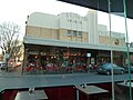 The Sun Theatre cinema in Yarraville
 -
 Interlocking Railway Crossing Gates at Yarraville station
 -
 Yarraville railway station
 -
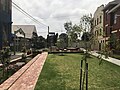
 Bellairs Avenue Playground in Yarraville
 -
 Birmingham Street Park in Yarraville


References[edit]
- ^ a b Australian Bureau of Statistics (28 June 2022). "Yarraville (Suburbs and Localities)". 2021 Census QuickStats. Retrieved 21 July 2022.
- ^ Manning, James (6 October 2020). "The 40 coolest neighbourhoods in the world". Time Out. Retrieved 27 November 2020.
- ^ "Yarraville industrial site for sale". Urban.com.au. 11 October 2011. Retrieved 9 December 2021.
- ^ "History derailed – Quadrant Online". quadrant.org.au. Retrieved 9 December 2021.
- ^ School of Historical Studies, Department of History. "Yarraville - Place - eMelbourne - The Encyclopedia of Melbourne Online". www.emelbourne.net.au. Retrieved 9 December 2021.
- ^ jimjin (12 August 2021). "Yiasou Yarraville: Greek hub's new chapter". Maribyrnong & Hobsons Bay. Retrieved 9 December 2021.
- ^ Economou, Alex (19 February 2020). "Readers respond well to call for stories of old Yarraville". NEOS KOSMOS. Retrieved 9 December 2021.
- ^ "Yarraville Village". maribyrnong.vic.gov.au. Archived from the original on 25 October 2009. Retrieved 23 January 2017.
- ^ "Wards". www.maribyrnong.vic.gov.au. Retrieved 9 December 2021.
- ^ "Yarraville Train Station". maribyrnong.vic.gov.au. Archived from the original on 8 January 2011. Retrieved 23 January 2017.
- ^ "Home". metlinkmelbourne.com.au. Retrieved 23 January 2017.
- ^ Yarraville Festival
- ^ Full Points Footy, Yarraville Seddon, retrieved 15 April 2009
- ^ "Giddey up for a big year". 28 January 2020.
- ^ Farouque, Farah (12 April 2012). "A straight shooter". smh.com.au. Retrieved 23 January 2017.
- ^ "Albert Tucker Biography". bightoncemetery.com. Retrieved 23 January 2017.
- ^ Morgan, Sasha Gattermayr, James Costa, Jade Murray and Helena (29 January 2023). "The breathtaking state of truck pollution in Melbourne's west". The Age. Retrieved 11 January 2024.
{{cite web}}: CS1 maint: multiple names: authors list (link) - ^ Victoria, Environment Protection Authority. "Dust issues at former Bradmill site in Yarraville | Environment Protection Authority Victoria". www.epa.vic.gov.au. Retrieved 11 January 2024.