
Terborg
Terborg | |
|---|---|
 Castle Wisch, Terborg | |
 Coat of arms | |
 Terborg Location in the Netherlands  Terborg Terborg (Netherlands) | |
| Coordinates: 51°55′13″N 6°21′27″E / 51.92028°N 6.35750°E | |
| Country | Netherlands |
| Province | Gelderland |
| Municipality | Oude IJsselstreek |
| Area | |
| • Total | 7.81 km2 (3.02 sq mi) |
| Elevation | 14 m (46 ft) |
| Population (2021)[1] | |
| • Total | 4,690 |
| • Density | 600/km2 (1,600/sq mi) |
| Time zone | UTC+1 (CET) |
| • Summer (DST) | UTC+2 (CEST) |
| Postal code | 7061[1] |
| Dialing code | 0315 |
Terborg is a small city in the Dutch province of Gelderland, in the Achterhoek region in the east of the Netherlands. It is located in the municipality of Oude IJsselstreek. The city lies about 7 km southeast of Doetinchem. The population is about 4600 inhabitants.
Terborg is situated on the river the Oude IJssel. In the centre of the little city lies Castle Wisch, founded in the 13th century (hence the name "Terborg" which means "by the castle"). In the southeast of the city, near Silvolde lies a small nature reserve called the Paasberg ("Easter Mountain"). Terborg has a train station on the train route Arnhem - Winterswijk, and trains call here twice every hour.
Terborg received city rights in 1419. The patron saint of the city is Saint George. Its coat of arms still is Saint George on a horse, killing a dragon.
Until 1813, Terborg was part of the fiefdom Wisch, together with the villages Silvolde en Varsseveld. Terborg was a separate municipality until 1818 when it was merged with Varsseveld into municipality Wisch (equal to the ancient fiefdom). In 2005 it formed municipality Oude IJsselstreek with municipality Gendringen.[3]
In 1945, the town's Chasdei Enosh synagogue was blown up and destroyed by Nazis. An exact replica of the historic building opened on 7 June 2018 in Mevo Horon Israel, inaugurated by Israeli descendants of Dutch Jews.[4] The old synagogue, on the Silvoldeseweg, was built in 1901.[5]
Gallery[edit]
-
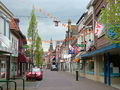 Main street
 -
 Terborg's coat of arms
 -
 Synagogue Teborg, 1957
 -
 Church of Terborg


.jpg)
References[edit]
- ^ a b c "Kerncijfers wijken en buurten 2021". Central Bureau of Statistics. Retrieved 23 March 2022.
- ^ "Postcodetool for 7061AA". Actueel Hoogtebestand Nederland (in Dutch). Het Waterschapshuis. Retrieved 23 March 2022.
- ^ Ad van der Meer and Onno Boonstra, Repertorium van Nederlandse gemeenten, KNAW, 2011.
- ^ "Replica of Dutch synagogue destroyed in WWII opens near Jerusalem" JTA June 13, 2018 https://www.jta.org/2018/06/13/news-opinion/replica-dutch-synagogue-destroyed-wwii-opens-near-jerusalem
- ^ van Velzen, Jaap; Uijenkruijer, Debby. Een ansicht uit de Mediene: joods leven in de Provincie. Joods Historisch Museum. p. 54. ISBN 9064712484.
| Authority control databases: National |
|---|