
Mount Parker (Hong Kong)
| Mount Parker | |
|---|---|
| 柏架山 | |
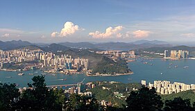
 Mount Parker from Kowloon in July 2008 | |
| Highest point | |
| Elevation | 532 m (1,745 ft) Hong Kong Principal Datum |
| Coordinates | 22°15′55.7″N 114°13′8.9″E / 22.265472°N 114.219139°E |
| Naming | |
| Native name | 柏架山 (Chinese) |
| Geography | |
 Mount Parker Location of Mount Parker in Hong Kong | |
| Location | |
| Mount Parker | |||||||||||||
|---|---|---|---|---|---|---|---|---|---|---|---|---|---|
| Chinese | 柏架山 | ||||||||||||
| |||||||||||||
Mount Parker is the second-highest peak (532 metres (1,745 ft)) on Hong Kong Island, after Victoria Peak (552 m (1,811 ft)).[1] It is the 40th-highest peak in the territory of Hong Kong.
Name[edit]
It is named after Admiral of the Fleet Sir William Parker, 1st Baronet, of Shenstone.[2]
Environment[edit]
Ecology[edit]
A rare native tree, the Hong Kong camellia (Camellia hongkongensis), can be found growing on Mount Parker,[3] while another species, Crapnell's camellia (Camellia crapnelliana), was first discovered on the peak.
Road restrictions[edit]
Much of the mountain is in a protected country park area. The roads that go up this mountain are access-restricted. Motorcycles, cars, bicycles, electric scooters without a special permit are not allowed on these roads, and the people who are caught may incur a penalty.
Gallery[edit]
-
 View from the top of Mount Parker toward Kowloon and Tseung Kwan O in September 2019
 -
 Mount Parker viewed from Sam Ka Tsuen Typhoon Shelter in 2008


References[edit]
- ^ "Lazy Hikes: Mount Parker Road to Tai Tam Road". South China Morning Post. 2012-09-27. Retrieved 2019-09-07.
- ^ "香港地方 | 地方 | 地方名稱(三)英官員命名地方". www.hk-place.com. Retrieved 2019-09-07.
- ^ "Tai Tam (Quarry Bay Ext.)". www.afcd.gov.hk. Retrieved 2019-09-07.
See also[edit]
- Kornhill
- Quarry Bay
- Tai Tam Country Park (Quarry Bay extension)
- List of mountains, peaks and hills in Hong Kong
- Geography of Hong Kong
| 900 meters or more | |
|---|---|
| 800 to 899 meters | |
| 700 to 799 meters | |
| 600 to 699 meters | |
| 500 to 599 meters |
|
| 400 to 499 meters (excerpt) |
|
| 300 to 399 meters (excerpt) |
|
| 200 to 299 meters (excerpt) |
|
| 100 to 199 meters (excerpt) |
|
| 99 meters or less (excerpt) |
|
| Collectively | |
This Hong Kong Island location article is a stub. You can help Wikipedia by expanding it. |
This article related to a mountain or hill in Hong Kong is a stub. You can help Wikipedia by expanding it. |