
Lochristi
Lochristi | |
|---|---|
 | |
 Flag  Coat of arms | |
Location of Lochristi  | |
 Lochristi Location in Belgium
Location of Lochristi in East Flanders  | |
| Coordinates: 51°06′N 03°50′E / 51.100°N 3.833°E | |
| Country | |
| Community | Flemish Community |
| Region | Flemish Region |
| Province | East Flanders |
| Arrondissement | Ghent |
| Government | |
| • Mayor | Yves Deswaene (Open VLD ) |
| • Governing party/ies | Open VLD |
| Area | |
| • Total | 60.66 km2 (23.42 sq mi) |
| Population (2018-01-01)[1] | |
| • Total | 22,300 |
| • Density | 370/km2 (950/sq mi) |
| Postal codes | 9080 |
| NIS code | 44034 |
| Area codes | 09 |
| Website | www.lochristi.be |
Lochristi (Dutch pronunciation: [ˌloːˈkrɪsti]) is a municipality located in the Belgian province of East Flanders. The municipality is composed of the towns of Beervelde, Lochristi proper, Zaffelare and Zeveneken. As of 2021, Lochristi had a total population of 22,621. The total area is 60.34 km2 (23.30 sq mi).[2]
Notable people[edit]
- Kwinten Clappaert (born 1988), footballer
Gallery[edit]
-
 Sint-Niklaaskerk
 -
 Street view
 -
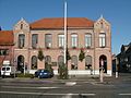
 Museum
 -
 Library

.JPG)

References[edit]
- ^ "Wettelijke Bevolking per gemeente op 1 januari 2018". Statbel. Retrieved 9 March 2019.
- ^ "Bevolking per statistische sector - Sector 44034". Statistics Belgium. Retrieved 8 May 2022.
External links[edit]
 Media related to Lochristi at Wikimedia Commons
- Official website (in Dutch)
Places adjacent to Lochristi | ||||||||||||||||
|---|---|---|---|---|---|---|---|---|---|---|---|---|---|---|---|---|
| ||||||||||||||||
| Aalst |  | |
|---|---|---|
| Dendermonde | ||
| Eeklo | ||
| Ghent | ||
| Oudenaarde | ||
| Sint-Niklaas | ||
| ||
| International | |
|---|---|
| Geographic | |
This East Flanders location article is a stub. You can help Wikipedia by expanding it. |