Wikipedia:Featured picture candidates/Sahara satellite.jpg
Sahara satellite.jpg[edit]

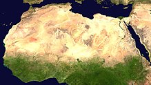
Not a self nom. I definitely think this image fills the striking/impressive, as welll as the beautiful/fascinating. The image is used at Sahara and demonstrate well the actual immensity of the desert, which many geographical maps does not quite carry over. - Circeus 13:17, Mar 18, 2005 (UTC)
- Nominate and support. - Circeus 13:17, Mar 18, 2005 (UTC)
- Oppose. This is actually a satellite-falsecolor composite as part of the Living Earth] project. It is manufactured. --Kitch 17:24, 18 Mar 2005 (UTC)
- It is indeed a satellite false-color image, as are Image:Mars_Valles_Marineris.jpeg, Image:Antarctica_satellite_globe.jpg, Image:Eagle_Nebula_-_NASA.jpg, and Image:Sunspot_TRACE.jpg (all featured already). There are many other mosaics, false-color images, and evendiagrams, if you can imagine, that have been featured. I don't think "manufactured" (presuably meaning by a more sophisticated process than capture by photographic film, development, scanning, cropping, and photoshop editing) is a reasonable criterion by which to judge potential Featured Pictures; no such criterion appears anywhere on the instructions. This picture provides an accurate and striking representation of the Sahara desert. --Andrew 21:04, Mar 18, 2005 (UTC)
- Note particularly the image Image:PearlHarbor_Sm.jpg (already featured) which is a false-color composite image of a geographical region. (Much less striking in my opinion). --Andrew 21:14, Mar 18, 2005 (UTC)
- Support. Good God, what have we done? --Andrew 21:04, Mar 18, 2005 (UTC)
- Upon further reading I see that the issue is certainly not as clear-cut as I thought it was. Oops. This discussion doesn't belong here anyway, so I'll drop it. In any case, the image is certainly striking! --Andrew 02:52, Mar 19, 2005 (UTC)
- Support I don't care how it was produced, the one question is : Does this pic illustrate particularly well the extent of the Sahara Desert. Answer YES! - Adrian Pingstone 22:17, 18 Mar 2005 (UTC)
- Support -Oh heavens it's "manufactured"! What exactly was he expecting, a handpainted watercolor by astronaut? It's a very good image.--Deglr6328 00:10, 19 Mar 2005 (UTC)
- Support. -- BRIAN0918 02:00, 19 Mar 2005 (UTC)
- Support. -- AllyUnion (talk) 08:38, 19 Mar 2005 (UTC)
- Support -So the picture is manufactured. So what? The machine that took the picture was manufactured. For that matter, so is the machine that we are all viewing it on. I don't see what the big deal is. TomStar81 09:20, 19 Mar 2005 (UTC)
- Support False-color image does not negate the extent of desertification in north Africa. Denni☯ 21:05, 2005 Mar 19 (UTC)
- Support. If it's a false-color image, that should be mentioned on the image page, and perhaps in the caption, but it in no way decreases the impact of the image on the article. —Korath (Talk) 19:14, Mar 20, 2005 (UTC)
- Support. James F. (talk) 23:02, 22 Mar 2005 (UTC)
- Support OK, it's a false colour image... Note on the description page and some captions should be enough. WB 05:13, Mar 23, 2005 (UTC)
- support --SPUI (talk) 08:39, 26 Mar 2005 (UTC)
- Comment: An uncropped, immense (8460x8900) version of this image showing the whole of Africa is at commons:Image:Africa satellite plane.jpg. (There's a much smaller version at that name here, currently on IFD.) —Korath (Talk) 01:20, Mar 28, 2005 (UTC)
