
Alcanena
Alcanena | |
|---|---|
.jpg) | |
 Flag  Coat of arms | |
 | |
| Coordinates: 39°28′N 8°40′W / 39.467°N 8.667°W | |
| Country | |
| Region | Centro |
| Intermunic. comm. | Médio Tejo |
| District | Santarém |
| Parishes | 7 |
| Government | |
| • President | Fernanda Asseiceira (PS) |
| Area | |
| • Total | 127.33 km2 (49.16 sq mi) |
| Population (2011) | |
| • Total | 13,868 |
| • Density | 110/km2 (280/sq mi) |
| Time zone | UTC±00:00 (WET) |
| • Summer (DST) | UTC+01:00 (WEST) |
| Local holiday | Ascension Day (date varies) |
| Website | http://www.cm-alcanena.pt |
Alcanena (Portuguese pronunciation: [alkɐˈnenɐ] ⓘ) is a Portuguese town and municipality of Ribatejo in Santarém District. The population in 2011 was 13,868,[1] in an area of 127.33 km².[2]
The current Mayor is Rui Anastácio (Partido Social Democrata) and the president of the Municipal Assembly is Silvestre Pereira (Socialist Party). The municipal holiday is Ascension Day.
Parishes[edit]
Administratively, the municipality is divided into 7 civil parishes (freguesias):[3]
- Alcanena e Vila Moreira
- Bugalhos
- Malhou, Louriceira e Espinheiro
- Minde
- Moitas Venda
- Monsanto
- Serra de Santo António
-
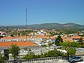 Serras de Aire e Candeeiros Natural Park as seen from Alcanena
 -

.jpg)
.jpg)
Notable people[edit]
- Alfredo Roque Gameiro (1864 in Minde - 1935) a painter, specialized in watercolors
- Maria da Conceição Moita (1937–2021) an educator and political activist
- Carlos Calado (born 1975) a Portuguese long jumper.
See also[edit]
- Casais Robustos – village located in Serras de Aire e Candeeiros Natural Park
- Serras de Aire e Candeeiros Natural Park – one of 30 protected areas in the county
References[edit]
- ^ Instituto Nacional de Estatística
- ^ "Áreas das freguesias, concelhos, distritos e país". Archived from the original on 2018-11-05. Retrieved 2018-11-05.
- ^ Diário da República. "Law nr. 11-A/2013, pages 552 6-7" (pdf) (in Portuguese). Retrieved 16 July 2014.
External links[edit]
- Local council official website Archived 2017-01-06 at the Wayback Machine
- Photos from ALCANENA
| Authority control databases: Geographic |
|---|
This Santarém location article is a stub. You can help Wikipedia by expanding it. |