
Alegre, Espírito Santo
Alegre is a municipality located in the Brazilian state of Espírito Santo. Its population was 29,975 (2020) and its area is 772 km² (298 sq mi).[1]
Alegre | |
|---|---|
 Municipal Building of Alegre | |
.png) Flag  Coat of arms | |
 Location in Espírito Santo state | |
 Alegre Location in Brazil | |
| Coordinates: 20°45′50″S 41°31′58″W / 20.76389°S 41.53278°W | |
| Country | Brazil |
| Region | Southeast |
| State | Espírito Santo |
| Established | 11 November 1890 |
| Area | |
| • Total | 772 km2 (298 sq mi) |
| Population (2020 [2]) | |
| • Total | 29,975 |
| • Density | 39/km2 (100/sq mi) |
| Time zone | UTC−3 (BRT) |
The municipality contains the Cachoeira da Fumaça State Park, created in 1984.[3]
Gallery[edit]
-
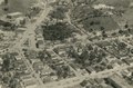 City of Alegre in 1958
 -
 Cachoeira da Fumaça


References[edit]
Capital: Vitória | ||||||||||
| Mesoregion Central |
|  | ||||||||
| Mesoregion Litoral Norte |
| |||||||||
| Mesoregion Noroeste |
| |||||||||
| Mesoregion Sul |
| |||||||||
This geographical article relating to Espírito Santo is a stub. You can help Wikipedia by expanding it. |