Ahurei
This article needs additional citations for verification. (December 2009) |

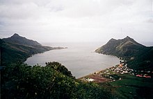
Ahuréi (sometimes called Ahurei, Ha'urei or Ha'uréi, latter two also show how it is pronounced), is the capital of Rapa and the rest of the Bass Islands of French Polynesia. It is located on both sides of the Baie d'Ahuréi.
Ahuréi consists of two suburbs: South Ahuréi, on the south side of the Baie d'Ahuréi, and North Ahuréi, on the north side of the Baie d'Ahuréi.
The town is the southernmost permanently inhabited settlement where French is an official language (not counting settlements with no civilian population).
Climate[edit]
The town features a humid subtropical climate (Köppen Cfa) that closely borders on a tropical rainforest climate (Köppen Af).
| Climate data for Ahurei | |||||||||||||
|---|---|---|---|---|---|---|---|---|---|---|---|---|---|
| Month | Jan | Feb | Mar | Apr | May | Jun | Jul | Aug | Sep | Oct | Nov | Dec | Year |
| Mean daily maximum °C (°F) | 25 (77) |
26 (78) |
26 (78) |
24 (75) |
22 (72) |
21 (70) |
20 (68) |
19 (67) |
20 (68) |
21 (69) |
22 (71) |
23 (74) |
22 (72) |
| Mean daily minimum °C (°F) | 22 (72) |
23 (73) |
22 (72) |
21 (69) |
19 (67) |
18 (64) |
17 (62) |
16 (61) |
17 (62) |
17 (63) |
19 (66) |
20 (68) |
19 (67) |
| Average precipitation mm (inches) | 270 (10.6) |
200 (7.8) |
260 (10.2) |
250 (10) |
260 (10.2) |
210 (8.1) |
240 (9.6) |
240 (9.6) |
200 (7.8) |
180 (6.9) |
200 (8) |
230 (9) |
2,750 (108.4) |
| Source: Weatherbase [1] | |||||||||||||
References[edit]
- ^ "Weatherbase: Historical Weather for Ahurei, French Polynesia". Weatherbase. 2011. Retrieved on November 24, 2011.
